Welcome to Whitney, a Temperate island in the The Coastal Waters of Southeast Alaska and British Columbia, part of the majestic Pacific Ocean. This guide offers a comprehensive overview of what makes Whitney unique – from its geography and climate to its population, infrastructure, and beyond. Dive into the details:
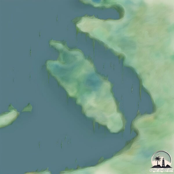
Geography and size of Whitney
Size: 3.862 km²
Coastline: 14.5 km
Ocean: Pacific Ocean
Sea: The Coastal Waters of Southeast Alaska and British Columbia
Continent: North America
Whitney is a Small Island spanning 3.9 km² with a coastline of 14.5 km.
Archipel: –
Tectonic Plate: North America – Covers North America and parts of the Atlantic and Arctic Oceans, characterized by diverse geological features and varying levels of seismic activity.
The geographic heart of the island is pinpointed at these coordinates:
Latitude: 57.23117827 / Longitude: -133.52798158
Climate and weather of Whitney
Climate Zone: Temperate
Climate Details: Temperate Oceanic Climate
Temperature: Warm Summer
Climate Characteristics: Known for its moderate year-round temperatures with ample rainfall and no dry season. Warm summers are characteristic.
Topography and nature of Whitney
Timezone: UTC-09:00
Timezone places: America/Anchorage
Max. Elevation: -67 m
Mean Elevation: -95 m
Vegetation: Evergreen Needleleaf Forest
Tree Coverage: 74%
The mean elevation is -95 m. Remarkably, this unique island barely emerges above the sea level, showcasing nature’s fascinating interplay with the ocean. The island is characterized by Plains: Flat, low-lying lands characterized by a maximum elevation of up to 200 meters. On islands, plains are typically coastal lowlands or central flat areas.
Dominating Vegetation: Evergreen Needleleaf Forest
Dominated by evergreen coniferous trees such as pines and firs, which retain their needle-like leaves throughout the year. These forests are often found in cooler climates. Whitney has a tree cover of 74 %.
Vegetation: 4 vegetation zones – Diverse Island
Four distinct vegetation zones mark these islands as ecologically diverse. They might feature varied landscapes such as forests, beaches, grasslands, and rocky areas. Such diversity reflects the island’s complex ecological interactions and varied habitats, which can support a rich array of wildlife and plant species.
Infrastructure and Travelling to Whitney
Does the island have a public airport? no.
There is no public and scheduled airport on Whitney. The nearest airport is Petersburg James A Johnson Airport, located 78 km away.
Does the island have a major port? no.
There are no major ports on Whitney. The closest major port is KAKE, approximately 53 km away.
The mean population of Whitney is 0 per km². Whitney is Uninhabited. The island belongs to United States of America.
Continuing your journey, Kupreanof is the next notable island, situated merely km away.
Whidbey Island's dark real-life drama hits Hollywood | FOX 13 Seattle
Hollywood is returning to the Puget Sound, but it's not for a story you'd want to turn into a tourist attraction. Subscribe to FOX 13 ...Whidbey Island's dark real-life drama hits Hollywood | FOX 13 Seattle
Hollywood is returning to the Puget Sound, but it's not for a story ...
Hollywood is returning to the Puget Sound, but it's not for a story you'd want to turn into a tourist attraction. Subscribe to FOX 13 ...
EXPLORING WHIDBEY ISLAND 🌲 Food & Nature Adventures in the PNW
Today we go on a day trip to the islands! We explore Whidbey Island ...
Today we go on a day trip to the islands! We explore Whidbey Island and drive through others. I filmed at Whidbey before, but ...
WHIDBEY ISLAND - A Washington travel guide
Welcome to Whidbey Island, Washington. In this cinematic travel guide, ...
Welcome to Whidbey Island, Washington. In this cinematic travel guide, we take you to some of our favorite places on this ...
Stop #4… 📍Whidbey Island, Washington
Stop #4… Whidbey Island, Washington We made this a day trip. We caught ...
Stop #4… Whidbey Island, Washington We made this a day trip. We caught the 8:00 ferry on a Saturday which was still early to ...
Deception Pass Bridge, Whidbey Island, WA in 4K
See aerial drone video of Deception Pass Bridge, connecting Whidbey ...
See aerial drone video of Deception Pass Bridge, connecting Whidbey Island, WA to the mainland. It opened in 1935 as part of ...
Is Whidbey Island Washington’s Best Kept Secret?
Come along with me on a stunning 3-day road trip across Whidbey ...
Come along with me on a stunning 3-day road trip across Whidbey Island, Washington! From the peaceful shores of Possession ...
48 hour Whidbey Island itinerary: NEAR SEATLE 🦀🧡🌊 #whidbeyisland #seattle #washington (AD)
'Bruiser' the Whidbey Island resident elk is in his yearly grumpy mood
People on Whidbey Island are being warned to stay away from one of the ...
People on Whidbey Island are being warned to stay away from one of the island's most popular residents because he's grumpy ...
FIRST TIME Whidbey Island Itinerary | Ferry | Drive In Theatre | Spent $100 | BEST Date idea
Kick starting fall with a trip to Whidbey Island! We caught the Ferry ...
Kick starting fall with a trip to Whidbey Island! We caught the Ferry to Whidbey island! The ferry was loaded with beautiful views of ...
The BEST of Whidbey Island | Day Trip to Washington's Largest Island
After 4 years of full-time travel, we have developed our own premium ...
After 4 years of full-time travel, we have developed our own premium leather passport wallet for couples and families.
The Truth About Whidbey Island
Think Whidbey Island is your escape from Washington's problems? Think ...
Think Whidbey Island is your escape from Washington's problems? Think again. The reality might surprise you. #WhidbeyIsland ...
10 Things You MUST DO in Whidbey Island, Washington! ☀️
Here are my top 10 things to do in Whidbey Island, Washington! ...
Here are my top 10 things to do in Whidbey Island, Washington! Locations Mentioned: Mukilteo Ferry Coupeville Front Street ...
Whidbey Island Washington | Hidden Gem Travel Vlog & Things to Do
Whidbey Island Washington | Hidden Gem Travel Vlog & Things to Do ✨ ...
Whidbey Island Washington | Hidden Gem Travel Vlog & Things to Do ✨ Whidbey Island is the perfect day trip from Seattle ...
Whidbey Island: totally unplanned, totally worth it. Hopped on the ferry, and let the day unfold.⛴️
Only elk on Whidbey Island in his yearly grumpy mood
People on Whidbey Island are being warned to stay away from one of the ...
People on Whidbey Island are being warned to stay away from one of the island's most popular residents because he's grumpy ...
5 Islands in 5 Days: Whidbey Island
Mimi and Jake head west to explore Whidbey Island, the fourth largest ...
Mimi and Jake head west to explore Whidbey Island, the fourth largest island in the lower 48 states.
Whidbey Island Washington: Top 10 Things To Do
Welcome to our channel! In this video, we're going to take you on an ...
Welcome to our channel! In this video, we're going to take you on an exciting virtual journey to Whidbey Island. Join us as we ...
Take a tour inside USS Whidbey Island, the 'Workhorse of the Navy'
The USS Whidbey Island sailed into Boston Thursday afternoon for Sail ...
The USS Whidbey Island sailed into Boston Thursday afternoon for Sail Boston festivities that begin on Saturday. Subscribe to ...
10 Reasons You Should Not Move to Whidbey Island, Washington
Thinking about moving to Whidbey Island, Washington? Before you pack ...
Thinking about moving to Whidbey Island, Washington? Before you pack your bags, watch this. In this video, I break down the real ...
Whidbey Island, WA Is Perfect for a Waterfront Getaway // Presented by Chevrolet
Three best friends reunite for a relaxing tour of the nature, food, ...
Three best friends reunite for a relaxing tour of the nature, food, and art that Whidbey Island, WA has to offer in the ...
What To Do On Whidbey Island
Whidbey Island is one of many gorgeous islands in Washington State. ...
Whidbey Island is one of many gorgeous islands in Washington State. It's an easy visit from Seattle and there is always plenty to ...
Whidbey Island seeing major power outages amid flood recovery
The island has seen widespread outages with many running off ...
The island has seen widespread outages with many running off generators. Residents are also dealing with flooding from ...
Living the Oak Harbor & North Whidbey Island Lifestyle
Thinking of calling Oak Harbor or north Whidbey Island home? Learn ...
Thinking of calling Oak Harbor or north Whidbey Island home? Learn more about this fabulous community and all the wonderful ...
Pros and Cons of Moving to Whidbey Island, Washington
I want to share with you the Pros and Cons of Moving to Whidbey ...
I want to share with you the Pros and Cons of Moving to Whidbey Island, Washington You've found yourself wondering and ...
Storm leaves Whidbey Island in the dark
Those living on Whidbey Island, specifically the southern portion, are ...
Those living on Whidbey Island, specifically the southern portion, are wondering when they'll get their power restored, after severe ...
United States of America is classified as Developed region: G7: Group of Seven – Major advanced economies, including Canada, France, Germany, Italy, Japan, the United Kingdom, and the United States. The level of income is High income: OECD.
News – Latest Updates and Headlines from Whitney
Stay informed with the most recent news and important headlines from Whitney. Here’s a roundup of the latest developments.
Loading...
Please note: The data used here has been primarily extracted from satellite readings. Deviations from exact values may occur, particularly regarding the height of elevations and population density. Land area and coastline measurements refer to average values at mean high tide.