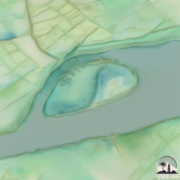
Welcome to Whitton, a Temperate island in the North Sea, part of the majestic Atlantic Ocean. This guide offers a comprehensive overview of what makes Whitton unique – from its geography and climate to its population, infrastructure, and beyond. Dive into the details:
Geography and size of Whitton
Size: 1.181 km²
Coastline: 4.4 km
Ocean: Atlantic Ocean
Sea: North Sea
Continent: Europe
Whitton is a Small Island spanning 1.2 km² with a coastline of 4.4 km.
Archipel: British Isles – A group of islands off the northwest coast of mainland Europe, including Great Britain, Ireland, and over 6,000 smaller islands, known for their rich history and cultural diversity.
Tectonic Plate: Eurasia – One of the world’s largest tectonic plates, the Eurasian Plate covers a significant portion of Europe and Asia. It’s characterized by diverse geological features, including the Ural Mountains, the European Plain, and the Himalayas formed from its collision with the Indian Plate.
The geographic heart of the island is pinpointed at these coordinates:
Latitude: 53.7135809 / Longitude: -0.66980243
Climate and weather of Whitton
Climate Zone: Temperate
Climate Details: Temperate Oceanic Climate
Temperature: Warm Summer
Climate Characteristics: Known for its moderate year-round temperatures with ample rainfall and no dry season. Warm summers are characteristic.
Topography and nature of Whitton
Timezone: UTC±00:00
Timezone places: Europe/London
Max. Elevation: 3 m
Mean Elevation: 2 m
Vegetation: Agricultural Mosaic
Tree Coverage: 54%
The mean elevation is 2 m. The highest elevation on the island reaches approximately 3 meters above sea level. The island is characterized by Plains: Flat, low-lying lands characterized by a maximum elevation of up to 200 meters. On islands, plains are typically coastal lowlands or central flat areas.
Dominating Vegetation: Agricultural Mosaic
A mix of cropland and natural vegetation, often seen in rural landscapes where agricultural fields are interspersed with patches of natural habitats. Whitton has a tree cover of 54 %.
Vegetation: 4 vegetation zones – Diverse Island
Four distinct vegetation zones mark these islands as ecologically diverse. They might feature varied landscapes such as forests, beaches, grasslands, and rocky areas. Such diversity reflects the island’s complex ecological interactions and varied habitats, which can support a rich array of wildlife and plant species.
Infrastructure and Travelling to Whitton
Does the island have a public airport? no.
There is no public and scheduled airport on Whitton. The nearest airport is Humberside Airport, located 38 km away.
Does the island have a major port? no.
There are no major ports on Whitton. The closest major port is GOOLE, approximately 17 km away.
The mean population of Whitton is 28 per km². Whitton is Gently Populated. The island belongs to United Kingdom.
Continuing your journey, Great Britain is the next notable island, situated merely km away.
The Air Up There - Whitton Island
Aerial Footage of Whitton Island Whitton Island is an island situated at the western end of the Humber Estuary in northern England ...The Air Up There - Whitton Island
Aerial Footage of Whitton Island Whitton Island is an island situated ...
Aerial Footage of Whitton Island Whitton Island is an island situated at the western end of the Humber Estuary in northern England ...
WHITTON: North Lincolnshire Parish #20 of 56
Here's the most Northerly village in all of Lincolnshire, situated at ...
Here's the most Northerly village in all of Lincolnshire, situated at the Northern termination of the Lincoln Cliff range of hills, about ...
Whitton Island and Trent Falls | Cinematic vides of Yorkshire| Aerial views of Britain |#drone
In northern England, two rivers, ouse and Trent finally reach the end ...
In northern England, two rivers, ouse and Trent finally reach the end of their journey, merging and forming the River Humber, the ...
KeepTurningLeft - winter on the Humber
Whitton Island
Provided to YouTube by DistroKid Whitton Island · Jachariah Thin End ...
Provided to YouTube by DistroKid Whitton Island · Jachariah Thin End Of The Wedge ℗ Derrean Records Released on: ...
Lindy Whitton - Crafts of the Island
Through 'Crafts of the Island' we wish to capture and share the ...
Through 'Crafts of the Island' we wish to capture and share the stories of Tassie's artistic souls. Essentially, celebrating their art ...
Tour of Whitton Youth Zone
We have six youth clubs around the borough. Find out more about what's ...
We have six youth clubs around the borough. Find out more about what's on offer at Whitton Youth Zone on the Achieving for ...
I found a SECRET ISLAND in theHunter: Call of the Wild! 🏝️😱😳 #shorts #cotw
Welcome to theHunter: Call of the Wild! Today I show you how to get to ...
Welcome to theHunter: Call of the Wild! Today I show you how to get to a secret island in theHunter: Call of the wild on Silver ...
Crane Park Island Nature Reserve, Whitton, London, September 2021
A short mini tour of London Wildlife Trust's Crane Park Island filmed ...
A short mini tour of London Wildlife Trust's Crane Park Island filmed on a sunny day in September 2021. The video shows the ...
SeaLink Infomercial - #thisismagneticisland 1
Oct Nov Dec edition of the SeaLink infomercial. For information how to ...
Oct Nov Dec edition of the SeaLink infomercial. For information how to be involved please email
whittonmatt@hotmail.com.
Touching the most expensive cotton on the planet!
Crane Park Island - Whitton England. Aix Galericulata. #wildlifeuk #nature #birds
Matt Whitton Film & Audio
SEALINK INFOMERCIAL - Ways to see Maggie
To be part of the Sealink infomercials..Please contact Matt at ...
BLACKTOFT: East Riding of Yorkshire Parish #19 of 172
Three left to cover with Goole postcodes in the East Riding of ...
Three left to cover with Goole postcodes in the East Riding of Yorkshire. The first one of those we're in today as we take a look at a ...
Earth Space View: Lisianski Island (Northwestern Hawaiian Islands)
This view was captured from the live stream from the ISS that can be ...
The Mysterious Galapagos Affair #history #interesting #mystery
Join this channel to get access to perks: ...
Magnetic Island, SeaLink Infomercial - July 2023
For more info how to have your business included on the SeaLink Ferry ...
For more info how to have your business included on the SeaLink Ferry Infomercial pease email :mattwhitton777@gmail.com.
The Galapagos Affair: Satan Came to Eden Official Trailer 1 (2014) - Documentary HD
The Galapagos Affair: Satan Came To Eden Official Trailer 1 (2014) - ...
The Galapagos Affair: Satan Came To Eden Official Trailer 1 (2014) - Documentary HD Subscribe to TRAILERS: ...
Bikepacker Marooned on Cramond Island - a 4K Microadventure!
I cycled to Cramond Island, off the coast of Edinburgh, Scotland when ...
I cycled to Cramond Island, off the coast of Edinburgh, Scotland when the tide was low and (deliberately!) marooned myself for the ...
Kure 300ft Rob Whitton with School of Jacks
Bishop Museum diver Robert Whitton films a school of Big-Lipped Jacks ...
Bishop Museum diver Robert Whitton films a school of Big-Lipped Jacks (Pseudocaranx cheilio) on a ledge 300 feet deep of Kure ...
Big Mama Sailing - Magnetic Island
Big Mama Sailing - Magnetic Island Contact Lisa - 0437206360.
Big Mama Sailing - Magnetic Island Contact Lisa - 0437206360.
SeaLink This Is Magnetic Island v2
Jan, Feb Mar 2019 edition of the SeaLink Infomercial For more info how ...
Jan, Feb Mar 2019 edition of the SeaLink Infomercial For more info how to have your business included ...
5 random facts about the Galápagos Islands you should know before visiting!
Interview with Delia Deriggi-Whitton
United Kingdom is classified as Developed region: G7: Group of Seven – Major advanced economies, including Canada, France, Germany, Italy, Japan, the United Kingdom, and the United States. The level of income is High income: OECD.
News – Latest Updates and Headlines from Whitton
Stay informed with the most recent news and important headlines from Whitton. Here’s a roundup of the latest developments.
Loading...
Please note: The data used here has been primarily extracted from satellite readings. Deviations from exact values may occur, particularly regarding the height of elevations and population density. Land area and coastline measurements refer to average values at mean high tide.