Welcome to Wilczek Land, a Polar island in the Barentsz Sea, part of the majestic Arctic Ocean. This guide offers a comprehensive overview of what makes Wilczek Land unique – from its geography and climate to its population, infrastructure, and beyond. Dive into the details:
Geography and size of Wilczek Land
Size: 1970 km²
Coastline: 383 km
Ocean: Arctic Ocean
Sea: Barentsz Sea
Continent: Europe
Wilczek Land is a Very Large Island spanning 1970 km² with a coastline of 383 km.
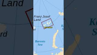
Archipel: Franz Josef Land – A Russian archipelago in the Arctic Ocean, known for its glaciated landscape and as a base for polar expeditions.
Tectonic Plate: Eurasia – One of the world’s largest tectonic plates, the Eurasian Plate covers a significant portion of Europe and Asia. It’s characterized by diverse geological features, including the Ural Mountains, the European Plain, and the Himalayas formed from its collision with the Indian Plate.
The geographic heart of the island is pinpointed at these coordinates:
Latitude: 80.62447649 / Longitude: 60.73608916
Climate and weather of Wilczek Land
Climate Zone: Polar
Climate Details: Ice Cap
Temperature: Cold
Climate Characteristics: The ice cap climate is the most extreme of the polar climates, characterized by a permanently frozen landscape. Temperatures rarely, if ever, rise above freezing, resulting in a barren, ice-covered environment with very little precipitation and no plant or animal life.
Topography and nature of Wilczek Land
Timezone: UTC+04:00
Timezone places: Europe/Moscow
Max. Elevation: 520 m
Mean Elevation: 237 m
Vegetation: Snow and Ice Covered
Tree Coverage: 4%
The mean elevation is 237 m. The highest elevation on the island reaches approximately 520 meters above sea level. The island is characterized by Plateau: Elevated flatlands rising sharply above the surrounding area, with a maximum elevation over 500 meters but a mean elevation less than 300 meters, forming unique highland areas on islands.
Dominating Vegetation: Snow and Ice Covered
These areas are permanently or seasonally covered in snow and ice, with little to no vegetation, such as polar regions and high mountains. Wilczek Land has a tree cover of 4 %.
Vegetation: 4 vegetation zones – Diverse Island
Four distinct vegetation zones mark these islands as ecologically diverse. They might feature varied landscapes such as forests, beaches, grasslands, and rocky areas. Such diversity reflects the island’s complex ecological interactions and varied habitats, which can support a rich array of wildlife and plant species.
Infrastructure and Travelling to Wilczek Land
Does the island have a public airport? no.
There is no public and scheduled airport on Wilczek Land. The nearest airport is Amderma Airport, located 1180 km away.
Does the island have a major port? no.
There are no major ports on Wilczek Land. The closest major port is PORT DIKSON, approximately 2190 km away.
The mean population of Wilczek Land is 0 per km². Wilczek Land is Uninhabited. The island belongs to Russia.
Continuing your journey, La Ronciere is the next notable island, situated merely km away.
The Final Landmass Found On Earth: Severnaya Zemlya
Despite the widespread use of satellites, GPS, Google Earth, and similar technologies, one might assume that every corner of our ...The Final Landmass Found On Earth: Severnaya Zemlya
Despite the widespread use of satellites, GPS, Google Earth, and ...
Despite the widespread use of satellites, GPS, Google Earth, and similar technologies, one might assume that every corner of our ...
The World's Northernmost Island Archipelago
Hello, In today's video, we take a look at the fascinating Geography ...
Hello, In today's video, we take a look at the fascinating Geography and History of the Northernmost Island Archipelago on Earth, ...
Examining Russia's Northernmost Island... Rudolf Island
At 81 degrees North, you find Russia's Rudolf Island, or Остров ...
At 81 degrees North, you find Russia's Rudolf Island, or Остров Рудольфа. This uninhabited island may look boring from the ...
Franz Josef Land - archipelago in Arctic Russia. HD Travel.
Franz Josef Land, Franz Joseph Land or Francis Joseph's Land (Russian: ...
Franz Josef Land, Franz Joseph Land or Francis Joseph's Land (Russian: Земля́ Фра́нца-Ио́сифа, tr. Zemlya Frantsa-Iosifa) is an ...
Franz Josef Land in the Russian Arctic (and Svalbard)
A trip to the top of geographic Europe, in the Russian Arctic: today ...
A trip to the top of geographic Europe, in the Russian Arctic: today we visit Franz Josef Land! This was the very first time - in the ...
Thousands of Years Frozen — The Whale Graveyard of the Russian Arctic
Thousands of Years Frozen — The Whale Graveyard of the Russian Arctic ...
Thousands of Years Frozen — The Whale Graveyard of the Russian Arctic In August 2024, a glacier on Wilczek Island in Russia's ...
Who Owns Antarctica? ❄️ Nobody's Land 🗺️
Have you ever wondered why the entire continent of Antarctica ❄️ ...
Have you ever wondered why the entire continent of Antarctica ❄️ doesn't belong to any country? This vast and icy landmass, ...
Russia's Wildest Dreams...🇷🇺🇷🇺
Russia #Russianhistory #Russia Geography #Russian #Europe ...
Russia #Russianhistory #Russia Geography #Russian #Europe #europeancountries #Geography #geographyfacts #Ukraine ...
The Most Shocking Secret of Earth's Invisible Island
What if I told you Earth has a hidden, invisible island larger than ...
What if I told you Earth has a hidden, invisible island larger than Europe?! Deep beneath the ocean lies Zealandia—a submerged ...
What Are The Main Islands In Franz Josef Land? - Polar Regions Uncovered
What Are The Main Islands In Franz Josef Land? Discover the ...
What Are The Main Islands In Franz Josef Land? Discover the fascinating world of Franz Josef Land, an Arctic archipelago that ...
The Weirdest Island on Earth!
Arktis 2012 Franz Josef Land Russland, Champ Insel, kugelrunde Geoden
Wilczek-Land, 80. Breitengrad.
Wilczek-Land, 80. Breitengrad.
FRANZ JOSEF LAND, Hayes Island : Amazing Planet
Hayes Island, Franz Josef Land by AMAZING PLANET / Filip Kulisev Filip ...
Hayes Island, Franz Josef Land by AMAZING PLANET / Filip Kulisev Filip strives to find and capture the most amazing sites ...
Остров Чамп. Земля Франца-Иосифа
Researchers found a frozen whale on a remote island. #seafood #diving #fishing #seaside
Researchers found a frozen whale on a remote island. #seafood #diving ...
Researchers found a frozen whale on a remote island. #seafood #diving #fishing #seaside 1.franz josef land whales. 2.found ...
Walrosse auf Svalbard
Walrosse sind vorsichtige, aber auch neugierige Tiere, die sich auch ...
Walrosse sind vorsichtige, aber auch neugierige Tiere, die sich auch wehren. Eine Walrosskuh hat auf Wilczek Land ...
BIGGEST 🏝️ ISLANDS by landmass in EUROPE #island #geography #ranking #europe #fyknowledge
List of the largest islands by area in Europe (continent): 1. Great ...
List of the largest islands by area in Europe (continent): 1. Great Britain: 229048 2. Iceland: 101826 3. Ireland: ...
Unforgettable Home You Won't Want to Misss
Majestic, mature trees set a breathtaking background for this ...
Majestic, mature trees set a breathtaking background for this beautiful classic residence in coveted EQUESTRIAN WOODS.
Anyone can Live here without a Visa!
Travelling to a Secret Island in Atlantic Ocean!
We travel to a place which is right in between where the continental ...
We travel to a place which is right in between where the continental plates of Europe and North America meet. Right in the middle ...
You Won't Believe this 13,000 sq ft home
Spectacular, CUSTOM MASTERPIECE nestled on approximately 1.3 Acres in ...
Spectacular, CUSTOM MASTERPIECE nestled on approximately 1.3 Acres in prestigious SILO RIDGE ESTATES. Boasting ...
Flying beyond the Ice Wall in Antarctica
Discover the world like never before in Microsoft Flight Simulator. ...
Discover the world like never before in Microsoft Flight Simulator. From breathtaking cockpit views to realistic flying experiences, ...
The only CUSTOM RANCH, inground pool, tiki bar video you need to watch....
Stunning, CUSTOM RANCH situated on a private nearly 1 acre lot ...
Stunning, CUSTOM RANCH situated on a private nearly 1 acre lot surrounded by towering majestic trees. Built with the highest ...
😊 Pozwól, że zrobię to za Ciebie! 🧡 Kot #shorts
Russia is classified as Emerging region: BRIC: Brazil, Russia, India, and China – Economies noted for their rapid growth and increasing influence on global affairs. The level of income is Upper middle income.
News – Latest Updates and Headlines from Wilczek Land
Stay informed with the most recent news and important headlines from Wilczek Land. Here’s a roundup of the latest developments.
Loading...
Social Media Posts about Wilczek Land
Loading...
Please note: The data used here has been primarily extracted from satellite readings. Deviations from exact values may occur, particularly regarding the height of elevations and population density. Land area and coastline measurements refer to average values at mean high tide.