Welcome to Williams, a Temperate island in the Great Australian Bight, part of the majestic Indian Ocean. This guide offers a comprehensive overview of what makes Williams unique – from its geography and climate to its population, infrastructure, and beyond. Dive into the details:
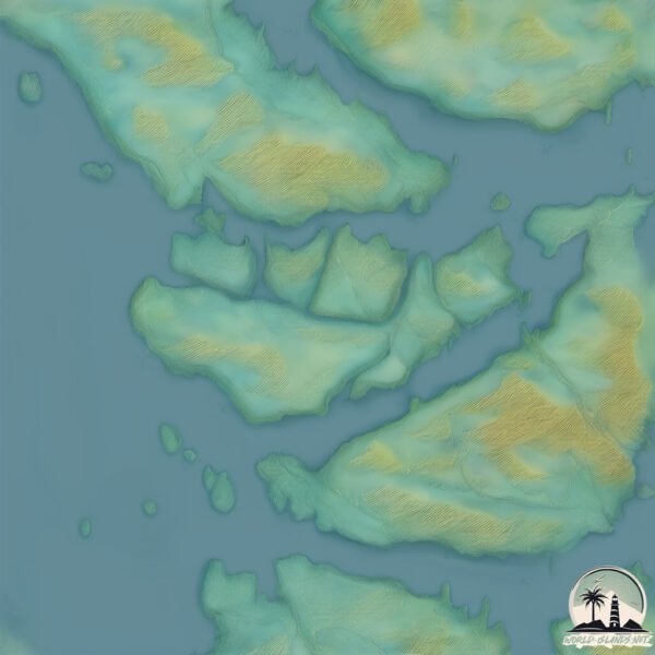
Geography and size of Williams
Size: 1.711 km²
Coastline: 8.1 km
Ocean: Indian Ocean
Sea: Great Australian Bight
Continent: Oceania
Williams is a Small Island spanning 1.7 km² with a coastline of 8.1 km.
Archipel: –
Tectonic Plate: Australia – A major tectonic plate covering Australia, New Zealand, and parts of the Indian and Pacific Oceans, known for its relative stability and occasional seismic activity.
The geographic heart of the island is pinpointed at these coordinates:
Latitude: -35.0291442 / Longitude: 135.97453287
Climate and weather of Williams
Climate Zone: Temperate
Climate Details: Warm-Summer Mediterranean Climate
Temperature: Warm Summer
Climate Characteristics: Characterized by warm, dry summers and mild, wet winters, typical of coastal areas with abundant sunshine Rain is more common in the winter months, maintaining a moderate climate.
Topography and nature of Williams
Timezone: UTC+09:30
Timezone places: Australia/Adelaide
Max. Elevation: 25 m
Mean Elevation: 15 m
Vegetation: Herbaceous Cover
Tree Coverage: 55%
The mean elevation is 15 m. The highest elevation on the island reaches approximately 25 meters above sea level. The island is characterized by Plains: Flat, low-lying lands characterized by a maximum elevation of up to 200 meters. On islands, plains are typically coastal lowlands or central flat areas.
Dominating Vegetation: Herbaceous Cover
Comprising mainly of grasses, herbs, and ferns, these areas are common in prairies, meadows, and savannas, and can vary widely in species composition. Williams has a tree cover of 55 %.
Vegetation: 4 vegetation zones – Diverse Island
Four distinct vegetation zones mark these islands as ecologically diverse. They might feature varied landscapes such as forests, beaches, grasslands, and rocky areas. Such diversity reflects the island’s complex ecological interactions and varied habitats, which can support a rich array of wildlife and plant species.
Infrastructure and Travelling to Williams
Does the island have a public airport? no.
There is no public and scheduled airport on Williams. The nearest airport is Port Lincoln Airport, located 47 km away.
Does the island have a major port? no.
There are no major ports on Williams. The closest major port is PORT LINCOLN, approximately 36 km away.
The mean population of Williams is 0 per km². Williams is Uninhabited. The island belongs to Australia.
Continuing your journey, Thistle is the next notable island, situated merely km away.
Discover Williams Island: Miami’s Hidden Gem of Luxury Living, Tennis, and Yachts!
Welcome to Williams Island: Miami's Best-Kept Secret of Luxury & Leisure! ✨ Ahhh, Williams Island—where Miami elegance ...Discover Williams Island: Miami’s Hidden Gem of Luxury Living, Tennis, and Yachts!
Welcome to Williams Island: Miami's Best-Kept Secret of Luxury & ...
Welcome to Williams Island: Miami's Best-Kept Secret of Luxury & Leisure! ✨ Ahhh, Williams Island—where Miami elegance ...
1000 Island Blvd Williams Island Condo Tour | Aventura Luxury Waterfront Living
1000 Island Blvd Williams Island Condo Tour | Luxury Waterfront Living ...
1000 Island Blvd Williams Island Condo Tour | Luxury Waterfront Living in Aventura 1000 Island Blvd is one of the premier luxury ...
Exceptional waterfront condo - Unit 2107 Williams Island
A sophisticated condominium built to suit the tropical climate and the ...
A sophisticated condominium built to suit the tropical climate and the waterfront location. The Williams Island Condo design ...
BELLINI i#1903 n AVENTURA, FLORIDA. WILLIAMS ISLAND's FINEST
Some Highlights include: 1) GREAT PRICE - This professionally ...
Some Highlights include: 1) GREAT PRICE - This professionally decorated unit (ARTEFACTO), perhaps the most beautiful in the ...
Williams Island Traffic Radar Intro
Staying safe at Williams Island club. We care about the safety of our ...
Staying safe at Williams Island club. We care about the safety of our residents and their families.
2000 WILLIAMS ISLAND PH - $ 2,200,000 SALE 954 600 0550 AVENTURA - FL 33160
Williams Island Condo Buildings - Aventura, Florida
With 8 luxury high-rise condos designed by Swedroe Architecture, ...
With 8 luxury high-rise condos designed by Swedroe Architecture, Williams Island is nestled on 84-acres in the exclusive enclave ...
Williams Islan Club Intro
Welcome to Williams Island, The Florida Riviera, nestled on 84 acres ...
Welcome to Williams Island, The Florida Riviera, nestled on 84 acres in Aventura, Florida. Williams Island offers an exclusive, ...
Bellini #1903 (High 1080 Definition)FOR SALE- Williams Island 4100 Island Blvd, Aventura, FL 33160
Aventura Williams Island, Florida, USA #floridabeachhomes #floridalifestyle
Williams Island 2000 #2503
Williams Island 2000 Building, Unit 2503.
Williams Island 2000 Building, Unit 2503.
WIlliams Island Food and Beverage Director
Meet our new Williams Island Club food & beverage director Scott Bester.
Meet our new Williams Island Club food & beverage director Scott Bester.
Driving through Williams Island Aventura Florida Feb 2024
Street view driving through Williams Island in #Aventura #florida.
Street view driving through Williams Island in #Aventura #florida.
Williams Island Condo For Sale Mediterranean Village B 305
This luxury residence has two bedrooms and two bathrooms, over 1940 ...
This luxury residence has two bedrooms and two bathrooms, over 1940 sqft and direct marina views of the yachts. Come home to ...
Williams Island 2600 Penthouse 5
Williams Island Marina - Aventura, Florida
Located in Aventura, Florida, midway between Miami and Fort ...
Located in Aventura, Florida, midway between Miami and Fort Lauderdale, Williams Island Marina is a high-end marina with 106 ...
WILLIAMS ISLAND 90 SPOT
90 Second Commercial for Williams Island.
90 Second Commercial for Williams Island.
Williams Island 2000 #809
Williams Island 2000 Building, Unit 809.
Williams Island 2000 Building, Unit 809.
Welcome to 1000 Williams Island
Welcome to 1000 Williams Island, an exquisite destination where luxury ...
Welcome to 1000 Williams Island, an exquisite destination where luxury living meets unparalleled waterfront beauty. Immerse ...
Truly Magnificent Two-Story Penthouse on Luxurious Williams Island
David Siddons | +1.305.508.0899 |
David@siddonsgroup.com This superbly finished and fully furnished penthouse unit at the ...
3000 Island Blvd #TS-3, Williams Island, FL 33160
An exceptional custom-designed 3/4 Bedroom, 4407 sq/ft Tower Suite ...
An exceptional custom-designed 3/4 Bedroom, 4407 sq/ft Tower Suite with 270 degree breathtaking wrap-around views of the ...
Williams Island, Aventura, Florida Sky Home For Sale-$2 Million Below Appraisal
mailto:jeff@jeffhillenbrand.com for more information! Exclusive ...
mailto:jeff@jeffhillenbrand.com for more information! Exclusive Williams Island, Aventura Florida Sky home for sale and offered at ...
Denise Shows Williams Island for the American Dream
As seen on the CW on November 12, 2023! Denise showed the Aventura ...
As seen on the CW on November 12, 2023! Denise showed the Aventura Mall and gave an exclusive tour of this beautiful ...
Williams Island | 3900 Island Boulevard Aventura FL | 3 bed 2.5 Bath Presented by: Maria V. Kafetzis
Welcome back to my channel! Today I present with this Luxury Corner ...
Welcome back to my channel! Today I present with this Luxury Corner Waterfront in the HEART of Aventura in Miami! Luxuriate an ...
Australia is classified as Developed region: nonG7: Developed economies outside of the Group of Seven, characterized by high income and advanced economic structures. The level of income is High income: OECD.
News – Latest Updates and Headlines from Williams
Stay informed with the most recent news and important headlines from Williams. Here’s a roundup of the latest developments.
Loading...
Please note: The data used here has been primarily extracted from satellite readings. Deviations from exact values may occur, particularly regarding the height of elevations and population density. Land area and coastline measurements refer to average values at mean high tide.