Wiloughby
Welcome to Wiloughby, a Continental island in the The Coastal Waters of Southeast Alaska and British Columbia, part of the majestic Pacific Ocean. This guide offers a comprehensive overview of what makes Wiloughby unique – from its geography and climate to its population, infrastructure, and beyond. Dive into the details:
- Geography and Size: Explore the island’s size and location.
- Climate and Weather: Weather patterns and temperature.
- Topography and Nature: Uncover the natural wonders of the island.
- Infrastructure and Travelling: Insights on reaching, staying, and making the most of your visit.
- News and Headlines: Latest News.
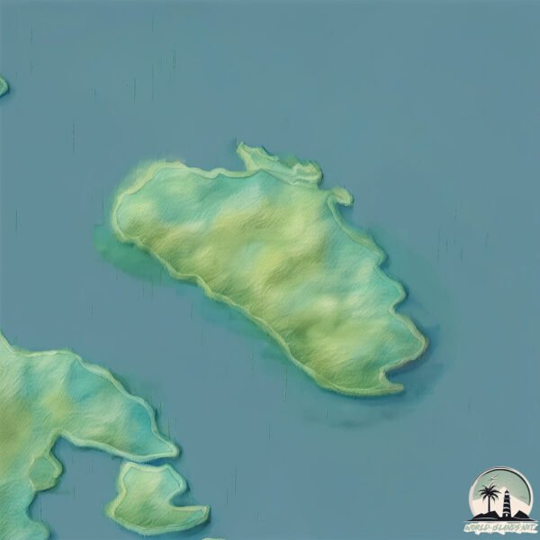
Geography and size of Wiloughby
Size: 11.4 km²
Coastline: 22.8 km
Ocean: Pacific Ocean
Sea: The Coastal Waters of Southeast Alaska and British Columbia
Continent: North America
Wiloughby is a Medium Island spanning 11 km² with a coastline of 23 km.
Archipel: –
Tectonic Plate: Pacific – The world’s largest tectonic plate, covering much of the Pacific Ocean, known for the Pacific Ring of Fire with extensive seismic and volcanic activity.
The geographic heart of the island is pinpointed at these coordinates:
Latitude: 58.58718644 / Longitude: -136.11797225
Climate and weather of Wiloughby
Climate Zone: Continental
Climate Details: Subarctic Climate
Temperature: Cold Summer
Climate Characteristics: Characterized by long, extremely cold winters and short, cool summers, often found in northern latitudes of North America and Eurasia.
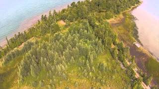
Topography and nature of Wiloughby
Timezone: UTC-09:00
Timezone places: America/Anchorage
Max. Elevation: 434 m
Mean Elevation: 189 m
Vegetation: Mixed Forest
Tree Coverage: 92%
The mean elevation is 189 m. The highest elevation on the island reaches approximately 434 meters above sea level. The island is characterized by Hills: Gently sloping landforms with rounded tops, having a maximum elevation between 200 and 500 meters. Hills contribute to a varied landscape on islands.
Dominating Vegetation: Mixed Forest
A combination of both deciduous and evergreen trees, often found in transitional zones between forest types. These forests offer a diverse habitat for various wildlife species. Wiloughby has a tree cover of 92 %.
Vegetation: 6 vegetation zones – Very Highly Diverse Island
Islands in this range are ecological powerhouses, showcasing a wide array of vegetation zones. Each zone, from lush rainforests to arid scrublands, coastal mangroves to mountainous regions, contributes to a complex and interdependent ecosystem. These islands are often hotspots of biodiversity, supporting numerous species and intricate ecological processes.
Infrastructure and Travelling to Wiloughby
Does the island have a public airport? no.
There is no public and scheduled airport on Wiloughby. The nearest airport is Gustavus Airport, located 45 km away.
Does the island have a major port? no.
There are no major ports on Wiloughby. The closest major port is ELFIN COVE, approximately 48 km away.
The mean population of Wiloughby is 0 per km². Wiloughby is Uninhabited. The island belongs to United States of America.
Continuing your journey, Lemesurier is the next notable island, situated merely km away.
Willoughby Island


United States of America is classified as Developed region: G7: Group of Seven – Major advanced economies, including Canada, France, Germany, Italy, Japan, the United Kingdom, and the United States. The level of income is High income: OECD.
News – Latest Updates and Headlines from Wiloughby
Stay informed with the most recent news and important headlines from Wiloughby. Here’s a roundup of the latest developments.
Please note: The data used here has been primarily extracted from satellite readings. Deviations from exact values may occur, particularly regarding the height of elevations and population density. Land area and coastline measurements refer to average values at mean high tide.