Welcome to Winyalkan, a Tropical island in the Indian Ocean, part of the majestic Indian Ocean. This guide offers a comprehensive overview of what makes Winyalkan unique – from its geography and climate to its population, infrastructure, and beyond. Dive into the details:
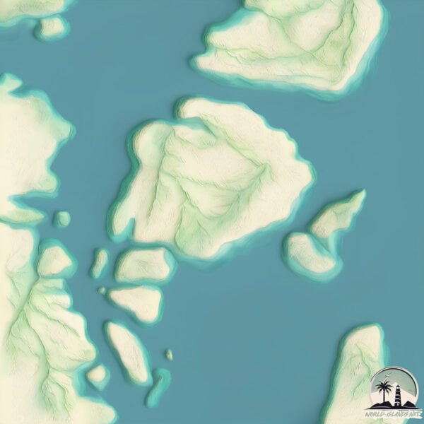
Geography and size of Winyalkan
Size: 2.225 km²
Coastline: 7.5 km
Ocean: Indian Ocean
Sea: Indian Ocean
Continent: Oceania
Winyalkan is a Small Island spanning 2.2 km² with a coastline of 7.5 km.
Archipel: –
Tectonic Plate: Australia – A major tectonic plate covering Australia, New Zealand, and parts of the Indian and Pacific Oceans, known for its relative stability and occasional seismic activity.
The geographic heart of the island is pinpointed at these coordinates:
Latitude: -14.55601397 / Longitude: 125.42673274
Climate and weather of Winyalkan
Climate Zone: Tropical
Climate Details: Tropical Savanna, Wet
Temperature: Hot
Climate Characteristics: Defined by distinct wet and dry seasons with high temperatures year-round. Pronounced rainfall occurs during the wet season, while the dry season is marked by drought.
Topography and nature of Winyalkan
Timezone: UTC+08:00
Timezone places: Australia/Perth
Max. Elevation: 53 m
Mean Elevation: 30 m
Vegetation: Open Woodland
Tree Coverage: 43%
The mean elevation is 30 m. The highest elevation on the island reaches approximately 53 meters above sea level. The island is characterized by Plains: Flat, low-lying lands characterized by a maximum elevation of up to 200 meters. On islands, plains are typically coastal lowlands or central flat areas.
Dominating Vegetation: Open Woodland
Characterized by sparsely distributed trees with open canopy allowing sunlight to penetrate, supporting grasses and shrubs underneath. Often found in drier or transitional environments. Winyalkan has a tree cover of 43 %.
Vegetation: 4 vegetation zones – Diverse Island
Four distinct vegetation zones mark these islands as ecologically diverse. They might feature varied landscapes such as forests, beaches, grasslands, and rocky areas. Such diversity reflects the island’s complex ecological interactions and varied habitats, which can support a rich array of wildlife and plant species.
Infrastructure and Travelling to Winyalkan
Does the island have a public airport? no.
There is no public and scheduled airport on Winyalkan. The nearest airport is East Kimberley Regional (Kununurra) Airport, located 388 km away.
Does the island have a major port? no.
There are no major ports on Winyalkan. The closest major port is WYNDHAM, approximately 313 km away.
The mean population of Winyalkan is 0 per km². Winyalkan is Uninhabited. The island belongs to Australia.
Continuing your journey, Wollaston is the next notable island, situated merely km away.
Kimberley Adventure Trailer Sailing Winyalkan Island to Cape Voltaire
On this leg of our adventure we explore Montague Sound, and area rich in aboriginal art. We visit many art sites in the Winyalkan ...Kimberley Adventure Trailer Sailing Winyalkan Island to Cape Voltaire
On this leg of our adventure we explore Montague Sound, and area rich ...
On this leg of our adventure we explore Montague Sound, and area rich in aboriginal art. We visit many art sites in the Winyalkan ...
E64 - Caves & Ancient Aboriginal Rock Art, Palm & Winyalkan Islands (oldest recorded boat painting)
This episode we leave Swift Bay and head further west to explore the ...
This episode we leave Swift Bay and head further west to explore the ancient Aboriginal art around Palm Island and Winyalkan ...
Kimberley Adventure - Trailer Sailing Raft Point to Camden Harbour
We leave Talbot Bay to cross the fierce currents of Collier Bay to ...
We leave Talbot Bay to cross the fierce currents of Collier Bay to reach Raft Point. After a few days enjoying Ruby and Little Ruby ...
Kimberley Adventure Trailer Sailing Derby to Hidden Island
Our Kimberley adventure starts at Derby with its claim to the 2nd ...
Our Kimberley adventure starts at Derby with its claim to the 2nd highest tides in the world. We juggle tides, rips and whirlpools to ...
Ep 303 | Caves and Aboriginal Rock Art, Swift Bay, Kimberley, Sailing Nutshell
We head ashore in Peanut to check out the Aboriginal rock at at Art ...
We head ashore in Peanut to check out the Aboriginal rock at at Art Creek. It's worth the hike up the rocks as the art is amazing!
E59 - 𝐎𝐬𝐛𝐨𝐫𝐧𝐞 𝐈𝐬𝐥𝐚𝐧𝐝𝐬, 𝐂𝐫𝐨𝐜𝐨𝐝𝐢𝐥𝐞𝐬, 𝐒𝐡𝐚𝐫𝐤𝐬 𝐚𝐧𝐝 𝐂𝐫𝐲𝐬𝐭𝐚𝐥𝐬 (𝐏𝐚𝐫𝐭 𝟏 𝐨𝐟 𝟐)
This episode we leave Freshwater Bay and sail around Hat Point in a ...
This episode we leave Freshwater Bay and sail around Hat Point in a fairly strong current where we see whirlpools going past No ...
Kimberley Adventure Trailer Sailing Cape Londonderry to King George River
We set off from Cape Tabolt bay before dawn to round the notorious ...
We set off from Cape Tabolt bay before dawn to round the notorious Cape Londonderry. We timed our rounding to coincide with ...
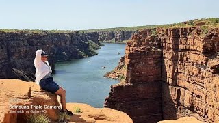
Expedition Cruise Kimberley I Australia Part1
We started cruising from Broome to Darwin with Coral Geographer ship. ...
We started cruising from Broome to Darwin with Coral Geographer ship. Along the way, we had amazing and unforgettable ...
Kimberley Adventure Trailer Sailing Cape Voltaire to Cape Londonderry
We round Cape Voltaire, one of the challenging capes with neap tides ...
We round Cape Voltaire, one of the challenging capes with neap tides and find the ebb tide against us but with placid seas.
Kimberley Adventure Trailer Sailing Hanover Bay to Prudhoe Island
With time ticking on we sail from Camden Harbour to Prudhoe Islands in ...
With time ticking on we sail from Camden Harbour to Prudhoe Islands in Montague Sound visiting Hanover Bay, Careening Bay ...
Who gives way on the water? Old Woman Island. Right of way boating.
We sailed our trailer sailer Mozart to Mudjimba Island, raised the ...
We sailed our trailer sailer Mozart to Mudjimba Island, raised the spinnaker for the second time and narrowly avoid a collision with ...
Aboriginal Rock Art as Historical Record
In this episode of The Mariner's Mirror Podcast 'Aborigines and the ...
In this episode of The Mariner's Mirror Podcast 'Aborigines and the Sea', Dr Sam Willis and Mack Mcarthy discuss how important ...
E61 - Crashing Our Drone at Mitchell River Falls (Part 1 of 2)
After leaving the Osborne Islands we sail across to the Mitchell River ...
After leaving the Osborne Islands we sail across to the Mitchell River famous for its spectacular waterfalls. We head up past the ...
E58 - Jar Island & Freshwater Bay (Vansittart Bay)
This episode we leave Mia Cove and explore the ancient Aboriginal art ...
This episode we leave Mia Cove and explore the ancient Aboriginal art on Jar Island, where we take a couple of hours climbing ...
E60 - Osborne Islands, The Arches, Snake Valley, Apartments, Birds & Buzzard Falls (Part 2 of 2)
This episode we explore from our anchorage at South West Rocks in the ...
This episode we explore from our anchorage at South West Rocks in the Osborne Islands region the Arches, Snake Valley, ...
E63 - Aboriginal Art & Patting a Shark, Swift Bay
This episode we leave the Mitchell River and head around Cape Voltaire ...
This episode we leave the Mitchell River and head around Cape Voltaire and into Swift Bay to explore the ancient Aboriginal Art ...
Kimberley sailing adventure on a Trailer Sailor Darwin to Derby 2019
Sailing from Darwin to Derby 2019 on our Trailer Sailer.
Sailing from Darwin to Derby 2019 on our Trailer Sailer.
E01 - Moving states and aboard our new home
Our first video showing us leaving Adelaide and driving to Airlie ...
Our first video showing us leaving Adelaide and driving to Airlie Beach in the Whitsundays to start off on our sailing adventure.
Trailer Sailing the Whitsundays Queensland Part 2
Sailing our RL 28 trailer sailer “Neringa” through the central ...
Sailing our RL 28 trailer sailer “Neringa” through the central Whitsundays. The journey continues into Hill Inlet at the northern End ...
Trailer Sailer to Pennekamp
Paul Van Ness and Carrboro Yacht Club hit the road in late December ...
Paul Van Ness and Carrboro Yacht Club hit the road in late December 2021 on another bucket list trip to the Florida Keys.
Australia is classified as Developed region: nonG7: Developed economies outside of the Group of Seven, characterized by high income and advanced economic structures. The level of income is High income: OECD.
News – Latest Updates and Headlines from Winyalkan
Stay informed with the most recent news and important headlines from Winyalkan. Here’s a roundup of the latest developments.
Loading...
Please note: The data used here has been primarily extracted from satellite readings. Deviations from exact values may occur, particularly regarding the height of elevations and population density. Land area and coastline measurements refer to average values at mean high tide.