Welcome to Woody, a Continental island in the Gulf of Alaska, part of the majestic Pacific Ocean. This guide offers a comprehensive overview of what makes Woody unique – from its geography and climate to its population, infrastructure, and beyond. Dive into the details:
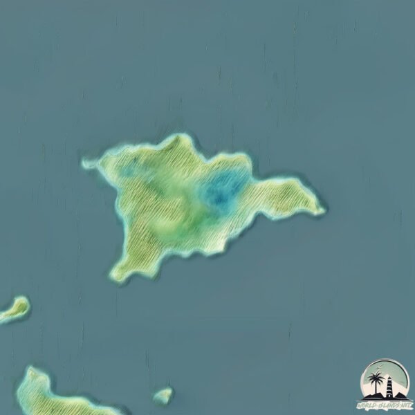
Geography and size of Woody
Size: 6.529 km²
Coastline: 21 km
Ocean: Pacific Ocean
Sea: Gulf of Alaska
Continent: North America
Woody is a Small Island spanning 6.5 km² with a coastline of 21 km.
Archipel: –
Tectonic Plate: North America – Covers North America and parts of the Atlantic and Arctic Oceans, characterized by diverse geological features and varying levels of seismic activity.
The geographic heart of the island is pinpointed at these coordinates:
Latitude: 57.77890527 / Longitude: -152.33662035
Climate and weather of Woody
Climate Zone: Continental
Climate Details: Subarctic Climate
Temperature: Cold Summer
Climate Characteristics: Characterized by long, extremely cold winters and short, cool summers, often found in northern latitudes of North America and Eurasia.
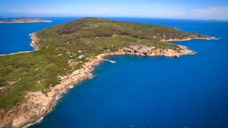
Topography and nature of Woody
Timezone: UTC-09:00
Timezone places: America/Anchorage
Max. Elevation: 132 m
Mean Elevation: 45 m
Vegetation: Evergreen Needleleaf Forest
Tree Coverage: 87%
The mean elevation is 45 m. The highest elevation on the island reaches approximately 132 meters above sea level. The island is characterized by Plains: Flat, low-lying lands characterized by a maximum elevation of up to 200 meters. On islands, plains are typically coastal lowlands or central flat areas.
Dominating Vegetation: Evergreen Needleleaf Forest
Dominated by evergreen coniferous trees such as pines and firs, which retain their needle-like leaves throughout the year. These forests are often found in cooler climates. Woody has a tree cover of 87 %.
Vegetation: 5 vegetation zones – Highly Diverse Island
With five different vegetation zones, these islands offer a rich tapestry of ecosystems. The variety could include dense forests, open meadows, wetlands, coastal zones, and more. This level of diversity supports an intricate web of life, with each zone playing a vital role in the overall ecological health and balance of the island.
Infrastructure and Travelling to Woody
Does the island have a public airport? no.
There is no public and scheduled airport on Woody. The nearest airport is Kodiak Airport, located 15 km away.
Does the island have a major port? no.
There are no major ports on Woody. The closest major port is KODIAK, approximately 4 km away.
The mean population of Woody is 0 per km². Woody is Uninhabited. The island belongs to United States of America.
Continuing your journey, Spruce is the next notable island, situated merely km away.
Destination WA - Woody Island
Of the 105 islands, Woody island Is the only island you are able to stay on and is a great way to experience this part of the world.Destination WA - Woody Island
Of the 105 islands, Woody island Is the only island you are able to ...
Of the 105 islands, Woody island Is the only island you are able to stay on and is a great way to experience this part of the world.
China's steady buildup on Woody Island
Satellite images show China's steady buildup on Woody Island, one of ...
Satellite images show China's steady buildup on Woody Island, one of the Paracel Islands in the South China Sea.(CSIS Asia ...
Destination WA - Woody Island
Chrissy travels to Woody Island. The Recherche Archipelago runs ...
Chrissy travels to Woody Island. The Recherche Archipelago runs approximately 230km from Esperance to the Great Australian ...
Destination WA - Woody Island
Chrissy heads to Woody Island, home to fantastic accommodation, ...
Chrissy heads to Woody Island, home to fantastic accommodation, snorkelling and walk trails.
Woody Island Resort
2024/2025 Official Promotional Video.
2024/2025 Official Promotional Video.
China Strikes a $42B US Tanker — But Pays With Woody Island in Ruins | US Navy
On September 23rd, 2025, the South China Sea turned into a ...
On September 23rd, 2025, the South China Sea turned into a battlefield. A Chinese Type-052D Destroyer launched 12 deadly ...
Full Length Promo Vid 2025 Update Final
The Woody Island Resort Experience- Updated October 2025.
The Woody Island Resort Experience- Updated October 2025.
WOODY ISLAND: Official Trailer
The trailer for the feature film Woody Island shot in and off the ...
The trailer for the feature film Woody Island shot in and off the coast of Esperance, Western Australia. Now available on DVD ...
The Six-Country Fight Over These Tiny, Terrible Islands
Woody Island Newfoundland aerial tour
A short drone video of Woody Island in Placentia Bay Newfoundland. ...
A short drone video of Woody Island in Placentia Bay Newfoundland. It's well known for the Woody Island resort. Music by: ...
An Overnight Retreat at Woody Island Resort - #SplitTheRock
I've driven past signs on the TCH for Woody Island Resort for years ...
I've driven past signs on the TCH for Woody Island Resort for years now, and never thought I'd actually get a chance to visit.
Australia's Golden Outback: get to know Woody Island Eco Tours
Located off Esperance, Woody Island is a nature lover's paradise and ...
Located off Esperance, Woody Island is a nature lover's paradise and Woody Island Eco Tours general manager Gen Spencer ...
Martha Stewart Visits Woody Island Resort - Wild Berries and Toutons!
In 1997 Martha Stewart traveled to the beautiful Canadian province of ...
In 1997 Martha Stewart traveled to the beautiful Canadian province of Newfoundland and Labrador. In this segment of her journey ...
WOODY ISLAND NL
Visit to Outport /NL.
Visit to Outport /NL.
Woody Island Small Video
Woody Island Tribal Council Retreat 2008 Quick Video.
Woody Island Tribal Council Retreat 2008 Quick Video.
Woody island
woody island, the site you should visit !!
woody island, the site you should visit !!
Clips from woody Island (esperance)
Woody Island Resort- Kids Review
Here what the children have to say!
Here what the children have to say!
Woody Island Rendezvous
A look at Woody Island Resort in the early 90's.
A look at Woody Island Resort in the early 90's.
Newfoundland Sportsman Visits Woody Island Resort: Dinner and Live Entertainment at the Lodge
In Season 3 of the Newfoundland Sportsman Show, hosts Dwight Blackwood ...
In Season 3 of the Newfoundland Sportsman Show, hosts Dwight Blackwood and Gord Follett made the trip to Woody Island ...
Exploring Woody Island | snorkelling | Hikeing
Join us this week as we head over to woody Island. We spend a few days ...
Join us this week as we head over to woody Island. We spend a few days exploring the island in the water and on the land.
Big Woody Island Fishing and Exploring
Fishing for Tuskies, baby Snapper, Sweetlip and a lucky bycatch of a ...
Fishing for Tuskies, baby Snapper, Sweetlip and a lucky bycatch of a Mackeral with a Prawn! We also swim into Big Woody Island ...
Woody Island Resort Corporate Promotional Video
Weddings on Woody Island
Woody Island Resort has been a popular destination for many beautiful ...
Woody Island Resort has been a popular destination for many beautiful weddings. It is the perfect venue for couples who would ...
United States of America is classified as Developed region: G7: Group of Seven – Major advanced economies, including Canada, France, Germany, Italy, Japan, the United Kingdom, and the United States. The level of income is High income: OECD.
News – Latest Updates and Headlines from Woody
Stay informed with the most recent news and important headlines from Woody. Here’s a roundup of the latest developments.
Loading...
Please note: The data used here has been primarily extracted from satellite readings. Deviations from exact values may occur, particularly regarding the height of elevations and population density. Land area and coastline measurements refer to average values at mean high tide.