Wuzi Dao
Welcome to Wuzi Dao, a Temperate island in the Eastern China Sea, part of the majestic Pacific Ocean. This guide offers a comprehensive overview of what makes Wuzi Dao unique – from its geography and climate to its population, infrastructure, and beyond. Dive into the details:
- Geography and Size: Explore the island’s size and location.
- Climate and Weather: Weather patterns and temperature.
- Topography and Nature: Uncover the natural wonders of the island.
- Infrastructure and Travelling: Insights on reaching, staying, and making the most of your visit.
- News and Headlines: Latest News.
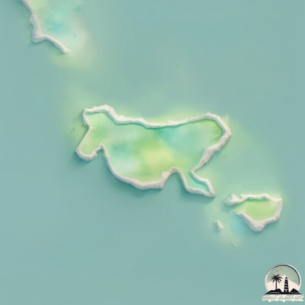
Geography and size of Wuzi Dao
Size: 0.345 km²
Coastline: 3.1 km
Ocean: Pacific Ocean
Sea: Eastern China Sea
Continent: Asia
Wuzi Dao is a Tiny Island spanning 0.345 km² with a coastline of 3.1 km.
Archipel: –
Tectonic Plate: Yangtze – A minor tectonic plate in East Asia, often considered a part of the Eurasian Plate. It’s primarily continental and covers the Yangtze River area in China, playing a significant role in the region’s geological stability.
The geographic heart of the island is pinpointed at these coordinates:
Latitude: 28.9843642 / Longitude: 121.76809834
Climate and weather of Wuzi Dao
Climate Zone: Temperate
Climate Details: Humid Subtropical Climate
Temperature: Hot Summer
Climate Characteristics: With continuous rainfall and hot summers, this climate is common in some coastal regions, supporting diverse vegetation.
Topography and nature of Wuzi Dao
Timezone: UTC+08:00
Timezone places: Australia/Perth
Max. Elevation: 9 m
Mean Elevation: 6 m
Vegetation: Sparse Vegetation
Tree Coverage: 75%
The mean elevation is 6 m. The highest elevation on the island reaches approximately 9 meters above sea level. The island is characterized by Plains: Flat, low-lying lands characterized by a maximum elevation of up to 200 meters. On islands, plains are typically coastal lowlands or central flat areas.
Dominating Vegetation: Sparse Vegetation
These regions have limited plant growth, typically due to extreme conditions like aridity or poor soils. Vegetation is scattered and consists of hardy plant species. Wuzi Dao has a tree cover of 75 %.
Vegetation: 1 vegetation zones – Minimal Diversity Island
These islands exhibit the most basic level of ecological diversity, often characterized by a single dominant vegetation type. This could be due to extreme environmental conditions, limited land area, or significant human impact. They represent unique ecosystems where specific species have adapted to thrive in these singular environments.
Infrastructure and Travelling to Wuzi Dao
Does the island have a public airport? no.
There is no public and scheduled airport on Wuzi Dao. The nearest airport is Taizhou Luqiao Airport, located 60 km away.
Does the island have a major port? no.
There are no major ports on Wuzi Dao. The closest major port is HAIMEN, approximately 48 km away.
The mean population of Wuzi Dao is 294 per km². Wuzi Dao is Moderately Inhabited. The island belongs to China.
Continuing your journey, Hua’ao Dao is the next notable island, situated merely km away.
Amazing Hainan | Wuzhishan


China is classified as Emerging region: BRIC: Brazil, Russia, India, and China – Economies noted for their rapid growth and increasing influence on global affairs. The level of income is Upper middle income.
News – Latest Updates and Headlines from Wuzi Dao
Stay informed with the most recent news and important headlines from Wuzi Dao. Here’s a roundup of the latest developments.
Please note: The data used here has been primarily extracted from satellite readings. Deviations from exact values may occur, particularly regarding the height of elevations and population density. Land area and coastline measurements refer to average values at mean high tide.