Xiaoping
Welcome to Xiaoping, a Continental island in the Yellow Sea, part of the majestic Pacific Ocean. This guide offers a comprehensive overview of what makes Xiaoping unique – from its geography and climate to its population, infrastructure, and beyond. Dive into the details:
- Geography and Size: Explore the island’s size and location.
- Climate and Weather: Weather patterns and temperature.
- Topography and Nature: Uncover the natural wonders of the island.
- Infrastructure and Travelling: Insights on reaching, staying, and making the most of your visit.
- News and Headlines: Latest News.
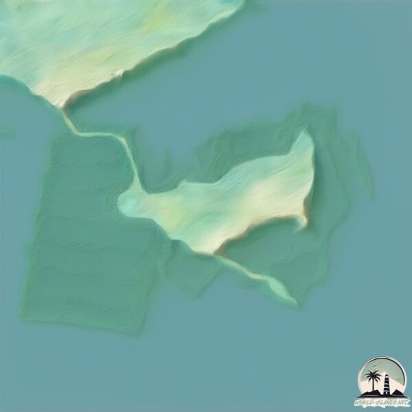
Geography and size of Xiaoping
Size: 1.009 km²
Coastline: 10.4 km
Ocean: Pacific Ocean
Sea: Yellow Sea
Continent: Asia
Xiaoping is a Small Island spanning 1 km² with a coastline of 10.4 km.
Archipel: –
Tectonic Plate: Eurasia – One of the world’s largest tectonic plates, the Eurasian Plate covers a significant portion of Europe and Asia. It’s characterized by diverse geological features, including the Ural Mountains, the European Plain, and the Himalayas formed from its collision with the Indian Plate.
The geographic heart of the island is pinpointed at these coordinates:
Latitude: 39.33684339 / Longitude: 122.33484493
Climate and weather of Xiaoping
Climate Zone: Continental
Climate Details: Monsoon-Influenced Hot-Summer Humid Continental Climate
Temperature: Hot Summer
Climate Characteristics: Hot summers with monsoon rains, contrasting with dry, cold winters. Typical of east Asian continental edges.
Topography and nature of Xiaoping
Timezone: UTC+08:00
Timezone places: Australia/Perth
Max. Elevation: 9 m
Mean Elevation: 4 m
Vegetation: Open Woodland
Tree Coverage: 10%
The mean elevation is 4 m. The highest elevation on the island reaches approximately 9 meters above sea level. The island is characterized by Plains: Flat, low-lying lands characterized by a maximum elevation of up to 200 meters. On islands, plains are typically coastal lowlands or central flat areas.
Dominating Vegetation: Open Woodland
Characterized by sparsely distributed trees with open canopy allowing sunlight to penetrate, supporting grasses and shrubs underneath. Often found in drier or transitional environments. Xiaoping has a tree cover of 10 %.
Vegetation: 3 vegetation zones – Moderately Diverse Island
These islands start to show a broader range of ecological niches. With three vegetation zones, they may offer a mix of ecosystems like coastal areas, inland woods, and perhaps a distinct wetland or dry area. This diversity supports a wider range of flora and fauna, making these islands more ecologically complex than those with minimal diversity.
Infrastructure and Travelling to Xiaoping
Does the island have a public airport? no.
There is no public and scheduled airport on Xiaoping. The nearest airport is Changhai Airport, located 37 km away.
Does the island have a major port? no.
There are no major ports on Xiaoping. The closest major port is DALIAN, approximately 87 km away.
The mean population of Xiaoping is 431 per km². Xiaoping is Moderately Inhabited. The island belongs to China.
Continuing your journey, Guanglu Dao is the next notable island, situated merely km away.
Xiaoping Island|Vlog| Dalian , China.


China is classified as Emerging region: BRIC: Brazil, Russia, India, and China – Economies noted for their rapid growth and increasing influence on global affairs. The level of income is Upper middle income.
News – Latest Updates and Headlines from Xiaoping
Stay informed with the most recent news and important headlines from Xiaoping. Here’s a roundup of the latest developments.
Please note: The data used here has been primarily extracted from satellite readings. Deviations from exact values may occur, particularly regarding the height of elevations and population density. Land area and coastline measurements refer to average values at mean high tide.