Welcome to Yaki Jima, a Temperate island in the Japan Sea, part of the majestic Pacific Ocean. This guide offers a comprehensive overview of what makes Yaki Jima unique – from its geography and climate to its population, infrastructure, and beyond. Dive into the details:
Geography and size of Yaki Jima
Size: 0.354 km²
Coastline: 4.3 km
Ocean: Pacific Ocean
Sea: Japan Sea
Continent: Asia
Yaki Jima is a Tiny Island spanning 0.354 km² with a coastline of 4.3 km.
Archipel: Japan – An East Asian archipelago comprising four main islands and numerous smaller ones, known for its rich history, technological advances, and distinct culture.
Tectonic Plate: Amur – A minor tectonic plate in the region of the Amur River at the border of Russia and China, involved in complex interactions with the Pacific and Eurasian plates.
The geographic heart of the island is pinpointed at these coordinates:
Latitude: 33.20406089 / Longitude: 129.58674091
Climate and weather of Yaki Jima
Climate Zone: Temperate
Climate Details: Humid Subtropical Climate
Temperature: Hot Summer
Climate Characteristics: With continuous rainfall and hot summers, this climate is common in some coastal regions, supporting diverse vegetation.
Topography and nature of Yaki Jima
Timezone: UTC+09:00
Timezone places: Asia/Tokyo
Max. Elevation: 11 m
Mean Elevation: 8 m
Vegetation: Evergreen Broadleaf Forest
Tree Coverage: 15%
The mean elevation is 8 m. The highest elevation on the island reaches approximately 11 meters above sea level. The island is characterized by Plains: Flat, low-lying lands characterized by a maximum elevation of up to 200 meters. On islands, plains are typically coastal lowlands or central flat areas.
Dominating Vegetation: Evergreen Broadleaf Forest
Characterized by dense, lush canopies of broadleaf trees that retain their leaves year-round. These forests are typically found in tropical and subtropical regions and are known for their high biodiversity. Yaki Jima has a tree cover of 15 %.
Vegetation: 2 vegetation zones – Low Diversity Island
Islands with two distinct vegetation zones offer slightly more ecological variety. These zones could be due to differences in elevation, moisture, or other environmental factors. While still limited in biodiversity, these islands may offer a contrast between the two zones, such as a coastline with mangroves and an inland area with grassland.
Infrastructure and Travelling to Yaki Jima
Does the island have a public airport? no.
There is no public and scheduled airport on Yaki Jima. The nearest airport is Nagasaki Airport, located 48 km away.
Does the island have a major port? no.
There are no major ports on Yaki Jima. The closest major port is SASEBO, approximately 14 km away.
The mean population of Yaki Jima is 556 per km². Yaki Jima is Densely Populated. The island belongs to Japan.
Continuing your journey, Hirado Shima is the next notable island, situated merely km away.
Abandoned Island in Japan (Hashima) 🏝️
Subscribe - @worldin2minutes Description: The video showcases the enigmatic beauty of Hashima Island, an abandoned ...Abandoned Island in Japan (Hashima) 🏝️
Subscribe - @worldin2minutes Description: The video showcases the ...
Subscribe - @worldin2minutes Description: The video showcases the enigmatic beauty of Hashima Island, an abandoned ...
📍Zamami Island, Okinawa, Japan #marinelife #traveltiktok #japan #okinawa #travelwithtrainpal #vuka
Zamami Island, Okinawa, Japan #marinelife #traveltiktok #japan ...
Zamami Island, Okinawa, Japan #marinelife #traveltiktok #japan #okinawa #travelwithtrainpal #vuka.
Places that don't feel real: Okinawa, Japan #travel #explore #nature #adventure #japan
adventure #explore #travel #nature #japan.
adventure #explore #travel #nature #japan.
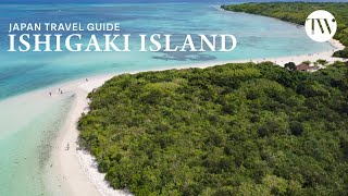
The Ultimate Ishigaki Island Travel Guide | Tokyo Weekender
We needed some time out from the hustle and bustle of Tokyo, so we ...
We needed some time out from the hustle and bustle of Tokyo, so we took a short flight down to Ishigaki Island (and neighboring ...
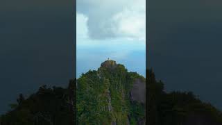
THE MOST MAGICAL PLACE IN JAPAN | Yakushima Island, Kagoshima | Travel Hidden Gem
How is this place real? Shiratani Unsuikyo is definitely THE MOST ...
How is this place real? Shiratani Unsuikyo is definitely THE MOST MAGICAL PLACE IN JAPAN located on Yakushima Island, ...
5 days in yakushima | local food, ancient cedar forrest, island reset
This week long retreat at Yakushima gave me a moment to breathe, soak ...
This week long retreat at Yakushima gave me a moment to breathe, soak in nature & absorb the peaceful vibes that radiated from ...
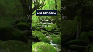
Yakushima: an Oasis of Unspoilt Nature | World Natural Heritage in Japan
Yakushima, located off the southern tip of Kagoshima, is a natural ...
Yakushima, located off the southern tip of Kagoshima, is a natural haven filled with enchanting forests, rich biodiversity, and ...
Exploring Hidden Yakushima Island | Japans Secret Paradise
Yakushima Island (屋久島) is a true island paradise, hidden in southern ...
Yakushima Island (屋久島) is a true island paradise, hidden in southern Japan. Yakushima is an island gem that holds many ...
📍Yakushima, Japan 🇯🇵 #shorts
japan #yakushima #YakushimaIsland #MagicalYakushima ...
japan #yakushima #YakushimaIsland #MagicalYakushima #YakushimaAdventure #YakushimaNature #YakushimaTravel ...
Ishigaki Grocery Store | Island Brand Store | You can find almost everything on this remote island
Ishigaki Island Tour in January 2022. Click here for more 4K Japan ...
Ishigaki Island Tour in January 2022. Click here for more 4K Japan Walks.
https://bit.ly/3oGo25V Follow on Social Media ...
Japan's Secret FairyTale Island You NEED To Visit
This location is absolutely incredible! Most people have never even ...
This location is absolutely incredible! Most people have never even heard of Yakushima, an absolute hidden gem in Southern ...
The soul of Japan |Yakushima|OFFICIAL TRAILER
People from all over the world agree that Japan is special. The ...
People from all over the world agree that Japan is special. The Japanese spiritual world — where people face nature and life itself ...
Yakushima,the island that inspired Princess Mononoke 🌲
Yakushima,the island that inspired Princess Mononoke Yakushima Island ...
Yakushima,the island that inspired Princess Mononoke Yakushima Island #japan #japon #일본 #япония #fypシ #fypシ゚viral ...
Explore Yakushima: Japan’s Wild Island Paradise | Nature, Hiking & Adventure in Kyushu
Just 70 minutes from Fukuoka by direct JAL eco-prop plane, Yakushima ...
Just 70 minutes from Fukuoka by direct JAL eco-prop plane, Yakushima feels like another world. Full report in English ...
Yakushima Island Frogs | Secret Wilderness: Japan | BBC Earth
On Yakushima Island, we discover that it's wet, has lots of beautiful ...
On Yakushima Island, we discover that it's wet, has lots of beautiful woodland, and frogs. Stunning documentary footage from the ...
Yakushima - Arriving in Japan's Remote Island
Join us on an unforgettable journey to Yakushima! We took a 4-hour ...
Join us on an unforgettable journey to Yakushima! We took a 4-hour ferry to this hidden gem, rented a car, enjoyed traditional ...
I Flew in Japan's Most Dangerous Airplane | Nightmare at 10,000 Feet
We fly over Japan's most active volcano, Sakurajima, before heading to ...
We fly over Japan's most active volcano, Sakurajima, before heading to the subtropical paradise of Yakushima island. BEHIND ...
Yakushima Island. #shorts #cedar #forest #japan #yakushima #islands
4 Days in Yakushima | Exploring Japan’s Most Magical Island
4 Days in Yakushima | Hiking Through The Island That Inspired Princess ...
4 Days in Yakushima | Hiking Through The Island That Inspired Princess Mononoke For four days, my brother and I explored ...
JAPAN: Could These Remote Islands Reveal Japan’s True Spirit? | Documentary - AMP
What secrets lie beyond Japan's famous cities and main islands? ...
What secrets lie beyond Japan's famous cities and main islands? Subscribe and join us on this journey around the world ...
Hiking with monkeys in Yakushima - Mount Miyanoura Hike
Some friends wanting to hike up to Mount Miyanoura with me in ...
Some friends wanting to hike up to Mount Miyanoura with me in Yakushima. You will never hike alone in Yakushima ...
I Spent 4 Days Hiking In The RAINIEST Place In Japan: Yakushima
Yakushima has some of the most ancient, wild and untamed landscapes ...
Yakushima has some of the most ancient, wild and untamed landscapes I've ever seen a hiking here was such an highlight.
What to do in Yakushima ? | Explore Japan
This video introduces Yakushima Island, a World Heritage Site located ...
This video introduces Yakushima Island, a World Heritage Site located in the south of Japan! I visited twice because of its great ...
A Foreigner Discovers the Magical Forest of Yakushima – Japan’s World Heritage Site
Yakushima is the first place in Japan to be designated as a UNESCO ...
Yakushima is the first place in Japan to be designated as a UNESCO World Natural Heritage site. With moss-covered forests, ...
Hiking in the Forest of Mononoke Princess, Yakushima, Japan 🇯🇵 #japan #mountains #nature
Japan is classified as Developed region: G7: Group of Seven – Major advanced economies, including Canada, France, Germany, Italy, Japan, the United Kingdom, and the United States. The level of income is High income: OECD.
News – Latest Updates and Headlines from Yaki Jima
Stay informed with the most recent news and important headlines from Yaki Jima. Here’s a roundup of the latest developments.
Loading...
Please note: The data used here has been primarily extracted from satellite readings. Deviations from exact values may occur, particularly regarding the height of elevations and population density. Land area and coastline measurements refer to average values at mean high tide.