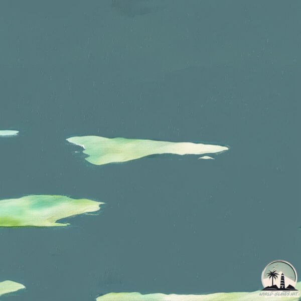
Welcome to Yermak, a Polar island in the Kara Sea, part of the majestic Arctic Ocean. This guide offers a comprehensive overview of what makes Yermak unique – from its geography and climate to its population, infrastructure, and beyond. Dive into the details:
Geography and size of Yermak
Size: 2.639 km²
Coastline: 14.5 km
Ocean: Arctic Ocean
Sea: Kara Sea
Continent: Asia
Yermak is a Small Island spanning 2.6 km² with a coastline of 14.5 km.
Archipel: –
Tectonic Plate: Eurasia – One of the world’s largest tectonic plates, the Eurasian Plate covers a significant portion of Europe and Asia. It’s characterized by diverse geological features, including the Ural Mountains, the European Plain, and the Himalayas formed from its collision with the Indian Plate.
The geographic heart of the island is pinpointed at these coordinates:
Latitude: 76.73230809 / Longitude: 94.85463522
Climate and weather of Yermak
Climate Zone: Polar
Climate Details: Tundra
Temperature: Cold
Climate Characteristics: The tundra climate features long, extremely cold winters and short, cool summers. Vegetation is limited to mosses, lichens, and small shrubs due to the low temperatures and short growing seasons. Biodiversity is low, but some specialized species thrive.
Topography and nature of Yermak
Timezone: UTC+08:00
Timezone places: Australia/Perth
Max. Elevation: 12 m
Mean Elevation: 3 m
Vegetation: Sparse Vegetation
Tree Coverage: 96%
The mean elevation is 3 m. The highest elevation on the island reaches approximately 12 meters above sea level. The island is characterized by Plains: Flat, low-lying lands characterized by a maximum elevation of up to 200 meters. On islands, plains are typically coastal lowlands or central flat areas.
Dominating Vegetation: Sparse Vegetation
These regions have limited plant growth, typically due to extreme conditions like aridity or poor soils. Vegetation is scattered and consists of hardy plant species. Yermak has a tree cover of 96 %.
Vegetation: 4 vegetation zones – Diverse Island
Four distinct vegetation zones mark these islands as ecologically diverse. They might feature varied landscapes such as forests, beaches, grasslands, and rocky areas. Such diversity reflects the island’s complex ecological interactions and varied habitats, which can support a rich array of wildlife and plant species.
Infrastructure and Travelling to Yermak
Does the island have a public airport? no.
There is no public and scheduled airport on Yermak. The nearest airport is Khatanga Airport, located 994 km away.
Does the island have a major port? no.
There are no major ports on Yermak. The closest major port is DUDINKA, approximately 1260 km away.
The mean population of Yermak is 0 per km². Yermak is Uninhabited. The island belongs to Russia.
Continuing your journey, Krasin is the next notable island, situated merely km away.
YITAHOME Kitchen Island with Drop Leaf
https://amzn.to/4oXyAKk The foldable drop leaf provides additional workspace when required. Simply raise it for a convenient ...YITAHOME Kitchen Island with Drop Leaf
https://amzn.to/4oXyAKk The foldable drop leaf provides additional workspace when required. Simply raise it for a convenient ...
YITAHOME Kitchen Island with Drop Leaf
https://amzn.to/4oXyAKk The foldable drop leaf provides additional workspace when required. Simply raise it for a convenient ...
ПОДРОБНОСТИ! Чеченцы похитили мажоров на Бали (Эксклюзив 2026)
Эксклюзивные кадры и расследование самого громкого похищения на Бали в ...
Эксклюзивные кадры и расследование самого громкого похищения на Бали в 2026 году. Как сын украинского ...
🤖Роботы Маска в ВСУ. Остров Эпштейна. Вакаров. Маг Ермак
Swivel Bar Stool with Low Back
https://amzn.to/44kuQL6 Crafted from solid wood with a strong metal footrest, these counter high chairs are made for long-term ...
Fantasy Ashtray Ash Holder
https://amzn.to/45q120C Made of durable resin material, sturdy construction even in rainy days. Welcome to the personal ...
Electric Cheese Grater Wireless
https://amzn.to/446imW4 This cheese grater electric has a powerful motor that shred fresh hard cheese in one step. Treat 1 lb in ...
Bathroom Storage Cabinet
https://amzn.to/3HFaEuL Top compartment for potted plants or cell phones, middle compartment for toiletries, bottom cabinet for ...
Swivel Bar Stool with Low Back
https://amzn.to/44kuQL6 Crafted from solid wood with a strong metal footrest, these counter high chairs are made for long-term ...
Life Story of Yermak - Metro Exodus
Metro Exodus best scenes ...
Metro Exodus best scenes ------------------------------------------------------------------------------------------------- For More Information Visit Our ...
Fantasy Ashtray Ash Holder
https://amzn.to/45q120C Made of durable resin material, sturdy construction even in rainy days. Welcome to the personal ...
Andriy Yermak - Traditional Way To Achieve Peace With Russia Is Not Possible
Speaking at Introducing Ukraine's Peace Formula during the Annual ...
Speaking at Introducing Ukraine's Peace Formula during the Annual Meeting at Davos 2023. Watch more here: ...
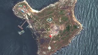
Ukraine to regain control of Snake Island after Russians withdraw
"KABOOM!" said Andriy Yermak, head of the presidential office in ...
"KABOOM!" said Andriy Yermak, head of the presidential office in Ukraine. "No Russian troops on the Snake Island anymore.
Freshman on Varsity be like 👀🏀 #shorts
(Via MADE Hoops ) #freshman #freshmanbelike #highschoolsports ...
(Via MADE Hoops ) #freshman #freshmanbelike #highschoolsports #basketball #highschoolbasketball #aintnoway.
Swivel Bar Stool with Low Back
https://amzn.to/44kuQL6 Crafted from solid wood with a strong metal footrest, these counter high chairs are made for long-term ...
Ultra Heavy Icebreaker Ship Crushes Ice
Hello Everybody Dock BC is back in the studio on Vancouver Island ...
Hello Everybody Dock BC is back in the studio on Vancouver Island editing Ultra Heavy Icebreaker Ship Crushes Ice shorts video.
Swivel Bar Stool with Low Back
https://amzn.to/44kuQL6 Crafted from solid wood with a strong metal footrest, these counter high chairs are made for long-term ...
Ukraine to regain control of Snake Island after Russians withdraw
"KABOOM!" said Andriy Yermak, head of the presidential office in ...
"KABOOM!" said Andriy Yermak, head of the presidential office in Ukraine. "No Russian troops on the Snake Island anymore.
Plans for Snake Island were announced in the OP
1:Plans for Snake Island were announced in the OP 2:Yermak told if a ...
1:Plans for Snake Island were announced in the OP 2:Yermak told if a meeting between Zelensky and Putin is being prepared ...
Fantasy Ashtray Ash Holder
https://amzn.to/45q120C Made of durable resin material, sturdy construction even in rainy days. Welcome to the personal ...
Fantasy Ashtray Ash Holder
https://amzn.to/45q120C Made of durable resin material, sturdy construction even in rainy days. Welcome to the personal ...
The Conqueror of Siberia: Yermak Timofeyevich
Created with Movavi Video Editor Plus ...
Electric Cheese Grater Wireless
https://amzn.to/446imW4 This cheese grater electric has a powerful motor that shred fresh hard cheese in one step. Treat 1 lb in ...
Sour Jujube Seed Barley Tea for Calm Sleep
https://amzn.to/442UH8V 100% Natural Herbs for Calm and Wellness- Crafted with natural ingredients like roasted barley, longan ...
52 Freed in Prisoner Exchange with Russia #shorts | VOA News
Fifty-two Ukrainians, including two former defenders of the Azovstal ...
Fifty-two Ukrainians, including two former defenders of the Azovstal steel plant, were released Saturday as part of a prisoner ...
Russia is classified as Emerging region: BRIC: Brazil, Russia, India, and China – Economies noted for their rapid growth and increasing influence on global affairs. The level of income is Upper middle income.
News – Latest Updates and Headlines from Yermak
Stay informed with the most recent news and important headlines from Yermak. Here’s a roundup of the latest developments.
Loading...
Please note: The data used here has been primarily extracted from satellite readings. Deviations from exact values may occur, particularly regarding the height of elevations and population density. Land area and coastline measurements refer to average values at mean high tide.