Prime Seal
Welcome to Prime Seal, a Temperate island in the Bass Strait, part of the majestic Pacific Ocean. This guide offers a comprehensive overview of what makes Prime Seal unique – from its geography and climate to its population, infrastructure, and beyond. Dive into the details:
- Geography and Size: Explore the island’s size and location.
- Climate and Weather: Weather patterns and temperature.
- Topography and Nature: Uncover the natural wonders of the island.
- Infrastructure and Travelling: Insights on reaching, staying, and making the most of your visit.
- News and Headlines: Latest News.
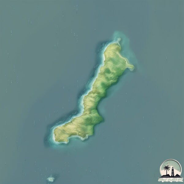
Geography and size of Prime Seal
Size: 13.2 km²
Coastline: 38.3 km
Ocean: Pacific Ocean
Sea: Bass Strait
Continent: Oceania
Prime Seal is a Medium Island spanning 13 km² with a coastline of 38 km.
Archipel: –
Tectonic Plate: Australia – A major tectonic plate covering Australia, New Zealand, and parts of the Indian and Pacific Oceans, known for its relative stability and occasional seismic activity.
The geographic heart of the island is pinpointed at these coordinates:
Latitude: -40.06637743 / Longitude: 147.75645529
Climate and weather of Prime Seal
Climate Zone: Temperate
Climate Details: Temperate Oceanic Climate
Temperature: Warm Summer
Climate Characteristics: Known for its moderate year-round temperatures with ample rainfall and no dry season. Warm summers are characteristic.
Topography and nature of Prime Seal
Timezone: UTC+10:00
Timezone places: Australia/Sydney
Max. Elevation: 115 m
Mean Elevation: 50 m
Vegetation: Sparse Vegetation with Trees/Shrubs
Tree Coverage: 61%
The mean elevation is 50 m. The highest elevation on the island reaches approximately 115 meters above sea level. The island is characterized by Plains: Flat, low-lying lands characterized by a maximum elevation of up to 200 meters. On islands, plains are typically coastal lowlands or central flat areas.
Dominating Vegetation: Sparse Vegetation with Trees/Shrubs
Areas where grasses and other herbaceous plants are prevalent, but with occasional presence of trees and shrubs. Often found in semi-arid regions or grasslands. Prime Seal has a tree cover of 61 %.
Vegetation: 6 vegetation zones – Very Highly Diverse Island
Islands in this range are ecological powerhouses, showcasing a wide array of vegetation zones. Each zone, from lush rainforests to arid scrublands, coastal mangroves to mountainous regions, contributes to a complex and interdependent ecosystem. These islands are often hotspots of biodiversity, supporting numerous species and intricate ecological processes.
Infrastructure and Travelling to Prime Seal
Does the island have a public airport? no.
There is no public and scheduled airport on Prime Seal. The nearest airport is Flinders Island Airport, located 23 km away.
Does the island have a major port? no.
There are no major ports on Prime Seal. The closest major port is PORT DALRYMPLE, approximately 151 km away.
The mean population of Prime Seal is 0 per km². Prime Seal is Uninhabited. The island belongs to Australia.
Continuing your journey, Badger is the next notable island, situated merely km away.
A3. EAST BASS STRAIT CRUISING: Blowing a dog off a chain - Prime Seal Island


Australia is classified as Developed region: nonG7: Developed economies outside of the Group of Seven, characterized by high income and advanced economic structures. The level of income is High income: OECD.
News – Latest Updates and Headlines from Prime Seal
Stay informed with the most recent news and important headlines from Prime Seal. Here’s a roundup of the latest developments.
- Body found in missing person search, police confirm - The Cairns Poston 23 March 2026
Body found in missing person search, police confirm The Cairns Post
- Seal Watching in Iceland - Guide to Icelandon 25 February 2026
Seal Watching in Iceland Guide to Iceland
- Motor vehicle accidents close Seal Island Bridge, Route 4 in Cape Breton for several hours | PNI Atlantic News - PNI Atlantic Newson 15 February 2026
Motor vehicle accidents close Seal Island Bridge, Route 4 in Cape Breton for several hours | PNI Atlantic News PNI Atlantic News
- Momoa and Bautista’s “The Wrecking Crew” needs more reality checks to make it consistently entertaining - nwasianweekly.comon 28 January 2026
Momoa and Bautista’s “The Wrecking Crew” needs more reality checks to make it consistently entertaining nwasianweekly.com
- Colby Cosh: The brewing Canada-U.S. fight over a disputed puffin island - National Poston 14 December 2025
Colby Cosh: The brewing Canada-U.S. fight over a disputed puffin island National Post
- The Best Places In America Where You Can See Seals (Other Than California), According To Travelers - islands.comon 13 November 2025
The Best Places In America Where You Can See Seals (Other Than California), According To Travelers islands.com
- Protecting Puffins in Maine Is an Emotional Commitment - Inside Climate Newson 3 November 2025
Protecting Puffins in Maine Is an Emotional Commitment Inside Climate News
- Anthony Albanese fails to seal defence treaty between Australia and PNG - The Guardianon 17 September 2025
Anthony Albanese fails to seal defence treaty between Australia and PNG The Guardian
- La Jolla Seals And Sea Lions: Exactly How To Visit [Map] - La Jolla Momon 27 May 2025
La Jolla Seals And Sea Lions: Exactly How To Visit [Map] La Jolla Mom
- 26 Best Movies About Ireland That You Need to Watch (2025) - Justin Plus Laurenon 22 May 2025
26 Best Movies About Ireland That You Need to Watch (2025) Justin Plus Lauren
Please note: The data used here has been primarily extracted from satellite readings. Deviations from exact values may occur, particularly regarding the height of elevations and population density. Land area and coastline measurements refer to average values at mean high tide.