Anjouan
Welcome to Anjouan, a Tropical island in the Mozambique Channel, part of the majestic Indian Ocean. This guide offers a comprehensive overview of what makes Anjouan unique – from its geography and climate to its population, infrastructure, and beyond. Dive into the details:
- Geography and Size: Explore the island’s size and location.
- Climate and Weather: Weather patterns and temperature.
- Topography and Nature: Uncover the natural wonders of the island.
- Infrastructure and Travelling: Insights on reaching, staying, and making the most of your visit.
- News and Headlines: Latest News.
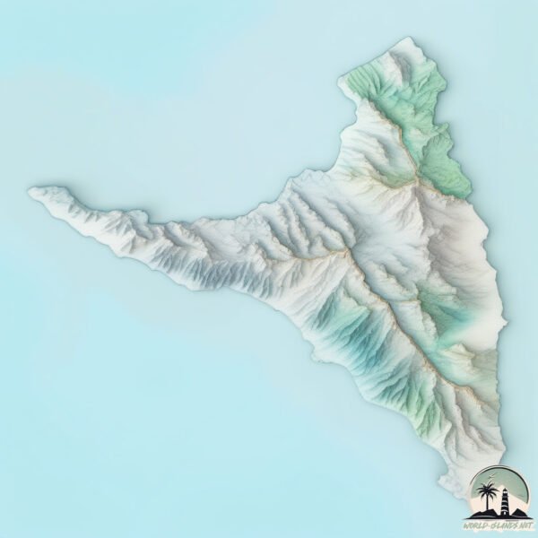
Geography and size of Anjouan
Size: 432.9 km²
Coastline: 142.3 km
Ocean: Indian Ocean
Sea: Mozambique Channel
Continent: Africa
Anjouan is a Large Island spanning 433 km² with a coastline of 142 km.
Archipel: Comoros – Located in the Indian Ocean between Madagascar and Mozambique, these volcanic islands are known for their unique blend of African, Arabic, and French influences.
Tectonic Plate: Somalia – A large tectonic plate covering the Horn of Africa and parts of the Indian Ocean, known for the East African Rift where it’s splitting away from the African Plate.
The geographic heart of the island is pinpointed at these coordinates:
Latitude: -12.22123606 / Longitude: 44.43714265
Climate and weather of Anjouan
Climate Zone: Tropical
Climate Details: Tropical Monsoon Climate
Temperature: Hot
Climate Characteristics: Characterized by heavy rainfall, high humidity, and uniformly high temperatures, but with a distinct short dry season. It features a seasonal reversal of prevailing wind directions.
Topography and nature of Anjouan
Timezone: UTC+03:00
Timezone places: Asia/Riyadh
Max. Elevation: 1595 m Ntingui
Mean Elevation: 416 m
Vegetation: Evergreen Broadleaf Forest
Tree Coverage: 65%
The mean elevation is 416 m. Dominating the island’s landscape, the majestic “Ntingui ” rises as the highest peak, soaring to impressive heights. The island is characterized by Mountains: High, steeply elevated landforms. Characterized by both a high maximum elevation (over 500 meters) and a high mean elevation, creating rugged, mountainous terrains on islands.
Dominating Vegetation: Evergreen Broadleaf Forest
Characterized by dense, lush canopies of broadleaf trees that retain their leaves year-round. These forests are typically found in tropical and subtropical regions and are known for their high biodiversity. Anjouan has a tree cover of 65 %.
Vegetation: 10 vegetation zones – Very Highly Diverse Island
Islands in this range are ecological powerhouses, showcasing a wide array of vegetation zones. Each zone, from lush rainforests to arid scrublands, coastal mangroves to mountainous regions, contributes to a complex and interdependent ecosystem. These islands are often hotspots of biodiversity, supporting numerous species and intricate ecological processes.
Infrastructure and Travelling to Anjouan
Does the island have a public airport? yes.
Anjouan has a public and scheduled airport. The following airports are located on this island: Ouani Airport.
Does the island have a major port? no.
There are no major ports on Anjouan. The closest major port is MOUTSAMOUDU, approximately 1 km away.
The mean population of Anjouan is 155 per km². Anjouan is Moderately Inhabited. The island belongs to Comoros.
The name of the island resonates across different cultures and languages. Here is how it is known around the world: Arabic: أنجوان; German: Anjouan; Spanish: Anjouan; French: Anjouan; Portuguese: Anjouan; Russian: Анжуан; Chinese: 昂儒昂岛
Continuing your journey, Mwali is the next notable island, situated merely km away.
Comoros is classified as Least developed region: Countries that exhibit the lowest indicators of socioeconomic development, with the lowest Human Development Index ratings. The level of income is Low income.
News – Latest Updates and Headlines from Anjouan
Stay informed with the most recent news and important headlines from Anjouan. Here’s a roundup of the latest developments.
Please note: The data used here has been primarily extracted from satellite readings. Deviations from exact values may occur, particularly regarding the height of elevations and population density. Land area and coastline measurements refer to average values at mean high tide.