Welcome to Big, a Temperate island in the Tasman Sea, part of the majestic Pacific Ocean. This guide offers a comprehensive overview of what makes Big unique – from its geography and climate to its population, infrastructure, and beyond. Dive into the details:
Geography and size of Big
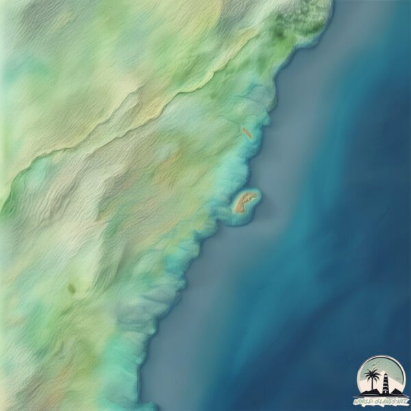
Size: 0.16 km²
Coastline: 1.8 km
Ocean: Pacific Ocean
Sea: Tasman Sea
Continent: Oceania
Big is a Tiny Island spanning 0.16 km² with a coastline of 1.8 km.
Archipel: –
Tectonic Plate: Australia – A major tectonic plate covering Australia, New Zealand, and parts of the Indian and Pacific Oceans, known for its relative stability and occasional seismic activity.
The geographic heart of the island is pinpointed at these coordinates:
Latitude: -35.06418119 / Longitude: 150.54578445
Climate and weather of Big
Climate Zone: Temperate
Climate Details: Temperate Oceanic Climate
Temperature: Warm Summer
Climate Characteristics: Known for its moderate year-round temperatures with ample rainfall and no dry season. Warm summers are characteristic.
Topography and nature of Big
Timezone: UTC+10:00
Timezone places: Australia/Sydney
Max. Elevation: 12 m
Mean Elevation: 4 m
Vegetation: Herbaceous Cover
Tree Coverage: 46%
The mean elevation is 4 m. The highest elevation on the island reaches approximately 12 meters above sea level. The island is characterized by Plains: Flat, low-lying lands characterized by a maximum elevation of up to 200 meters. On islands, plains are typically coastal lowlands or central flat areas.
Dominating Vegetation: Herbaceous Cover
Comprising mainly of grasses, herbs, and ferns, these areas are common in prairies, meadows, and savannas, and can vary widely in species composition. Big has a tree cover of 46 %.
Vegetation: 3 vegetation zones – Moderately Diverse Island
These islands start to show a broader range of ecological niches. With three vegetation zones, they may offer a mix of ecosystems like coastal areas, inland woods, and perhaps a distinct wetland or dry area. This diversity supports a wider range of flora and fauna, making these islands more ecologically complex than those with minimal diversity.
Infrastructure and Travelling to Big
Does the island have a public airport? no.
There is no public and scheduled airport on Big. The nearest airport is Shellharbour Airport, located 17 km away.
Does the island have a major port? no.
There are no major ports on Big. The closest major port is PORT KEMBLA, approximately 1 km away.
The mean population of Big is 288 per km². Big is Moderately Inhabited. The island belongs to Australia.
Continuing your journey, Kooragang is the next notable island, situated merely km away.
BIG ISLAND Hawaii Travel Guide 2025: 16 THINGS TO KNOW BEFORE YOU GO
Enjoy planning your trip to the Big Island! See our Big Island playlist for more information and open the Description for all the ...BIG ISLAND Hawaii Travel Guide 2025: 16 THINGS TO KNOW BEFORE YOU GO
Enjoy planning your trip to the Big Island! See our Big Island ...
Enjoy planning your trip to the Big Island! See our Big Island playlist for more information and open the Description for all the ...
21 Things to Do Around the Big Island, Hawaii | Two residents share their favorite things to do
Here are our favorite things to do in Big Island, Hawaii in 2022. This ...
Here are our favorite things to do in Big Island, Hawaii in 2022. This is your guided tour of what the Island of Hawaii has to offer ...
Hawaii's Big Island Vacation Travel Guide | Expedia
Hawaii's Big Island – The “Big Island” of Hawaii is (you guessed it) ...
Hawaii's Big Island – The “Big Island” of Hawaii is (you guessed it) the largest of the Hawaiian Islands and offers a stunning array ...
What To Do Big Island Hawaii 🌴 Ultimate Travel Guide
Dive into the Big Island Hawaii Unforgettable Adventures on the Big ...
Dive into the Big Island Hawaii Unforgettable Adventures on the Big Island: 10 Must-Do Experiences In this video, we'll embark on ...
❌Don't go to HAWAII without watching THIS... (5 things to do on the Big Island Hawaii)
Why You Need to Visit the Big Island - Hawaii 5 Day Travel Guide & Tips
Join us on our 5 day adventure through the incredible Big Island! ...
Join us on our 5 day adventure through the incredible Big Island! Hawaii, Hawaii (nicknamed "The Big Island" or "Kona" from the ...
The Big Island Ultimate Guide (w Maps) - Everything You Need to Know and More!!
Printable and Digital Guides Available... ...
BIG ISLAND of HAWAII Travel Guide: Everything to Know!
Watch this before you go to Hawaii's Big Island! This travel guide ...
Watch this before you go to Hawaii's Big Island! This travel guide breaks down everything you need to know: transportation, ...
ONE WEEK on the BIG ISLAND, HAWAII | BEST THINGS to DO, EAT & SEE | Travel Guide
ONE WEEK on the BIG ISLAND, HAWAII | BEST THINGS to DO, EAT & SEE | ...
ONE WEEK on the BIG ISLAND, HAWAII | BEST THINGS to DO, EAT & SEE | Travel Guide MANTA RAY SNORKEL TOUR: ...
Quick Tour of Hawaii Big Island’s Hidden Gems! 🌴✨
Quick Tour of Hawaii Big Island's Hidden Gems! ✨ #shorts #hawaii ...
Quick Tour of Hawaii Big Island's Hidden Gems! ✨ #shorts #hawaii #bigisland #usa hawaii big island hawaii hawaii travel ...
11 Things to Do on The Big Island That No One Else is Sharing
If you are heading to the Big Island of Hawaii, you've likely seen ...
If you are heading to the Big Island of Hawaii, you've likely seen list after list of the same things over and over. That's great - but ...
Our Big Island Hawaii Adventure: Food, Itinerary & Travel Tips (Plus Crazy Flight Deal!)
Aloha! In this visual, we embark on an unforgettable adventure across ...
Aloha! In this visual, we embark on an unforgettable adventure across the breathtaking Big Island (Hawai'i Island) of Hawaii!
Living on the Big Island: Our 2026 Predictions
Aloha! It's Eric & Julie with 365Hawaii We're out around the Big ...
Aloha! It's Eric & Julie with 365Hawaii We're out around the Big Island talking about what really happened this year and what we ...
15 Big Island things to do in just 3 days
This road map shows you where the must-see places are on the Big ...
This road map shows you where the must-see places are on the Big Island, how to get to them and what to expect when you arrive ...
4 things to do on Hawaii’s Big Island🌺🐚 #hawaii #konahawaii #hawaiiisland #bigislandhawaii #kona
Top 10 Best Things to Do on the Big Island, Hawaii - Travel Video 2024
Welcome to our ultimate guide on the Best Things to Do on the Big ...
Welcome to our ultimate guide on the Best Things to Do on the Big Island of Hawaii! Whether you're planning your dream vacation ...
7 Days on HAWAII's BIG ISLAND: What to See, Do & Eat
These are the best things to do & eat on the Big Island of Hawaii! ...
These are the best things to do & eat on the Big Island of Hawaii! Embark with us on a whirlwind 7-day family adventure across ...
Hawaii Big Island Travel Guide: 18 BEST Things To Do On Hawaii's Big Island
This Hawaii Big Island travel guide shares the best things to do in ...
This Hawaii Big Island travel guide shares the best things to do in Hawaii Big Island. -------------- How to travel more and visit your ...
5 Best Luxury Resorts on the Big Island, Hawaii | Four Seasons, Mauna Lani, Fairmont Orchid, Westin
Is a luxury Big Island resort in your future? These places are why ...
Is a luxury Big Island resort in your future? These places are why they call the Kohala Coast the Gold Coast. Links to learn more ...
5 REAL Hidden Food Gems on the Big Island of Hawaii
hawaii #bigislandhawaii #foodie Greetings, travelers. In this video, I ...
hawaii #bigislandhawaii #foodie Greetings, travelers. In this video, I am featuring 5 real food gems on the Big Island of Hawaii, ...
5 Days on the Big Island, Ultimate Hawaii Itinerary!
Grab our travel day shirts here! Please wake me for in-flight snacks: ...
Kīlauea Lava Fountains Erupt, Civil Defense Radio Message Issued (Feb. 15, 2026)
HAWAIʻI VOLCANOES NATIONAL PARK - Episode 42 in the ongoing summit ...
HAWAIʻI VOLCANOES NATIONAL PARK - Episode 42 in the ongoing summit eruption got underway at around 1:50 p.m. HST on ...
Big Island Of Hawaii Hidden Gems
Big Island Of Hawaii Hidden Gems Big Island Food Tour - ...
Kailua-Kona, Hawaii - 4K Walking Tour | Big Island USA 🇺🇸 | December 2024
Shooting date: December 18, 2024 - 12:25 PM Weather: Sunny ...
Shooting date: December 18, 2024 - 12:25 PM Weather: Sunny Temperature: 26°C / 78.8°F Camera: DJI OSMO POCKET3 00:00 ...
Why Hawaii’s Islands Aren’t Connected by Boats 🚢 Ocean Mystery 🌊
Hawaii travel hides a surprising fact, you can't move between the ...
Hawaii travel hides a surprising fact, you can't move between the islands by boat! The 8 main Hawaiian Islands, 6 open to ...
Australia is classified as Developed region: nonG7: Developed economies outside of the Group of Seven, characterized by high income and advanced economic structures. The level of income is High income: OECD.
News – Latest Updates and Headlines from Big
Stay informed with the most recent news and important headlines from Big. Here’s a roundup of the latest developments.
Loading...
Please note: The data used here has been primarily extracted from satellite readings. Deviations from exact values may occur, particularly regarding the height of elevations and population density. Land area and coastline measurements refer to average values at mean high tide.