Chaunggyi
Welcome to Chaunggyi, a Tropical island in the Andaman or Burma Sea, part of the majestic Indian Ocean. This guide offers a comprehensive overview of what makes Chaunggyi unique – from its geography and climate to its population, infrastructure, and beyond. Dive into the details:
- Geography and Size: Explore the island’s size and location.
- Climate and Weather: Weather patterns and temperature.
- Topography and Nature: Uncover the natural wonders of the island.
- Infrastructure and Travelling: Insights on reaching, staying, and making the most of your visit.
- News and Headlines: Latest News.
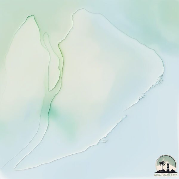
Geography and size of Chaunggyi
Size: 161.7 km²
Coastline: 70.1 km
Ocean: Indian Ocean
Sea: Andaman or Burma Sea
Continent: Asia
Chaunggyi is a Large Island spanning 162 km² with a coastline of 70 km.
Archipel: –
Tectonic Plate: India – A major tectonic plate that initially moved northward at a rapid pace before colliding with the Eurasian Plate. This collision is responsible for the uplift of the Himalayas and the Tibetan Plateau.
The geographic heart of the island is pinpointed at these coordinates:
Latitude: 16.30157594 / Longitude: 96.00453152
Climate and weather of Chaunggyi
Climate Zone: Tropical
Climate Details: Tropical Monsoon Climate
Temperature: Hot
Climate Characteristics: Characterized by heavy rainfall, high humidity, and uniformly high temperatures, but with a distinct short dry season. It features a seasonal reversal of prevailing wind directions.
Topography and nature of Chaunggyi
Timezone: UTC+06:30
Timezone places: Asia/Rangoon
Max. Elevation: 5 m
Mean Elevation: 4 m
Vegetation: Cultivated Land
Tree Coverage: 21%
The mean elevation is 4 m. The highest elevation on the island reaches approximately 5 meters above sea level. The island is characterized by Plains: Flat, low-lying lands characterized by a maximum elevation of up to 200 meters. On islands, plains are typically coastal lowlands or central flat areas.
Dominating Vegetation: Cultivated Land
Areas dedicated to agricultural activities, growing crops like grains, vegetables, and fruits. These lands are usually human-modified landscapes. Chaunggyi has a tree cover of 21 %.
Vegetation: 5 vegetation zones – Highly Diverse Island
With five different vegetation zones, these islands offer a rich tapestry of ecosystems. The variety could include dense forests, open meadows, wetlands, coastal zones, and more. This level of diversity supports an intricate web of life, with each zone playing a vital role in the overall ecological health and balance of the island.
Infrastructure and Travelling to Chaunggyi
Does the island have a public airport? no.
There is no public and scheduled airport on Chaunggyi. The nearest airport is Yangon International Airport, located 60 km away.
Does the island have a major port? no.
There are no major ports on Chaunggyi. The closest major port is RANGOON, approximately 46 km away.
The mean population of Chaunggyi is 206 per km². Chaunggyi is Moderately Inhabited. The island belongs to Myanmar.
Continuing your journey, Hmau Bhi Kyun is the next notable island, situated merely km away.
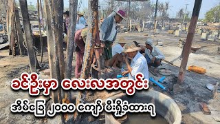
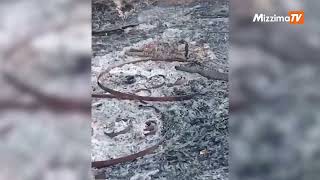
ခင်ဦးမှာ လေးလအတွင်း အိမ်ခြေ ၂၀၀၀ ကျော် မီးရှို့ခံထားရ

Myanmar is classified as Least developed region: Countries that exhibit the lowest indicators of socioeconomic development, with the lowest Human Development Index ratings. The level of income is Low income.
News – Latest Updates and Headlines from Chaunggyi
Stay informed with the most recent news and important headlines from Chaunggyi. Here’s a roundup of the latest developments.
Please note: The data used here has been primarily extracted from satellite readings. Deviations from exact values may occur, particularly regarding the height of elevations and population density. Land area and coastline measurements refer to average values at mean high tide.