Da Armona
Welcome to Da Armona, a Temperate island in the North Atlantic Ocean, part of the majestic Atlantic Ocean. This guide offers a comprehensive overview of what makes Da Armona unique – from its geography and climate to its population, infrastructure, and beyond. Dive into the details:
- Geography and Size: Explore the island’s size and location.
- Climate and Weather: Weather patterns and temperature.
- Topography and Nature: Uncover the natural wonders of the island.
- Infrastructure and Travelling: Insights on reaching, staying, and making the most of your visit.
- News and Headlines: Latest News.
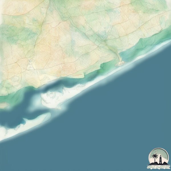
Geography and size of Da Armona
Size: 6.135 km²
Coastline: 19.8 km
Ocean: Atlantic Ocean
Sea: North Atlantic Ocean
Continent: Europe
Da Armona is a Small Island spanning 6.1 km² with a coastline of 19.8 km.
Archipel: –
Tectonic Plate: North America – Covers North America and parts of the Atlantic and Arctic Oceans, characterized by diverse geological features and varying levels of seismic activity.
The geographic heart of the island is pinpointed at these coordinates:
Latitude: 37.02754602 / Longitude: -7.78021306
Climate and weather of Da Armona
Climate Zone: Temperate
Climate Details: Hot-Summer Mediterranean Climate
Temperature: Hot Summer
Climate Characteristics: Characterized by hot, dry summers and mild, wet winters, typical of coastal areas with abundant sunshine.
Topography and nature of Da Armona
Timezone: UTC±00:00
Timezone places: Europe/Lisbon
Max. Elevation: 5 m
Mean Elevation: 2 m
Vegetation: Sparse Vegetation
Tree Coverage: 28%
The mean elevation is 2 m. The highest elevation on the island reaches approximately 5 meters above sea level. The island is characterized by Plains: Flat, low-lying lands characterized by a maximum elevation of up to 200 meters. On islands, plains are typically coastal lowlands or central flat areas.
Dominating Vegetation: Sparse Vegetation
These regions have limited plant growth, typically due to extreme conditions like aridity or poor soils. Vegetation is scattered and consists of hardy plant species. Da Armona has a tree cover of 28 %.
Vegetation: 7 vegetation zones – Very Highly Diverse Island
Islands in this range are ecological powerhouses, showcasing a wide array of vegetation zones. Each zone, from lush rainforests to arid scrublands, coastal mangroves to mountainous regions, contributes to a complex and interdependent ecosystem. These islands are often hotspots of biodiversity, supporting numerous species and intricate ecological processes.
Infrastructure and Travelling to Da Armona
Does the island have a public airport? no.
There is no public and scheduled airport on Da Armona. The nearest airport is Faro Airport, located 18 km away.
Does the island have a major port? no.
There are no major ports on Da Armona. The closest major port is FARO, approximately 14 km away.
The mean population of Da Armona is 9 per km². Da Armona is Gently Populated. The island belongs to Portugal.
Continuing your journey, Deserta is the next notable island, situated merely km away.
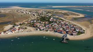
What Makes Armona Island the Ultimate Algarve Escape?


Portugal is classified as Developed region: nonG7: Developed economies outside of the Group of Seven, characterized by high income and advanced economic structures. The level of income is High income: OECD.
News – Latest Updates and Headlines from Da Armona
Stay informed with the most recent news and important headlines from Da Armona. Here’s a roundup of the latest developments.
Please note: The data used here has been primarily extracted from satellite readings. Deviations from exact values may occur, particularly regarding the height of elevations and population density. Land area and coastline measurements refer to average values at mean high tide.