Kala
Welcome to Kala, a Tropical island in the Andaman or Burma Sea, part of the majestic Indian Ocean. This guide offers a comprehensive overview of what makes Kala unique – from its geography and climate to its population, infrastructure, and beyond. Dive into the details:
- Geography and Size: Explore the island’s size and location.
- Climate and Weather: Weather patterns and temperature.
- Topography and Nature: Uncover the natural wonders of the island.
- Infrastructure and Travelling: Insights on reaching, staying, and making the most of your visit.
- News and Headlines: Latest News.
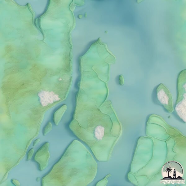
Geography and size of Kala
Size: 50 km²
Coastline: 52.7 km
Ocean: Indian Ocean
Sea: Andaman or Burma Sea
Continent: Asia
Kala is a Medium Island spanning 50 km² with a coastline of 53 km.
Archipel: Mergui Archipelago – Located in the Andaman Sea off the coast of Myanmar, known for their pristine beaches, diverse marine life, and Moken sea nomads.
Tectonic Plate: Sunda – Extends across Southeast Asia, encompassing parts of the Sunda Shelf, known for its interaction with the Australian Plate, contributing to volcanic activity in Indonesia.
The geographic heart of the island is pinpointed at these coordinates:
Latitude: 12.45166601 / Longitude: 98.49162796
Climate and weather of Kala
Climate Zone: Tropical
Climate Details: Tropical Monsoon Climate
Temperature: Hot
Climate Characteristics: Characterized by heavy rainfall, high humidity, and uniformly high temperatures, but with a distinct short dry season. It features a seasonal reversal of prevailing wind directions.
Topography and nature of Kala
Timezone: UTC+06:30
Timezone places: Asia/Rangoon
Max. Elevation: 34 m
Mean Elevation: 13 m
Vegetation: Mangrove Forest
Tree Coverage: 73%
The mean elevation is 13 m. The highest elevation on the island reaches approximately 34 meters above sea level. The island is characterized by Plains: Flat, low-lying lands characterized by a maximum elevation of up to 200 meters. On islands, plains are typically coastal lowlands or central flat areas.
Dominating Vegetation: Mangrove Forest
Found in coastal areas and river deltas, these unique wetland ecosystems are adapted to saline conditions and are crucial for coastal protection and biodiversity. Kala has a tree cover of 73 %.
Vegetation: 9 vegetation zones – Very Highly Diverse Island
Islands in this range are ecological powerhouses, showcasing a wide array of vegetation zones. Each zone, from lush rainforests to arid scrublands, coastal mangroves to mountainous regions, contributes to a complex and interdependent ecosystem. These islands are often hotspots of biodiversity, supporting numerous species and intricate ecological processes.
Infrastructure and Travelling to Kala
Does the island have a public airport? no.
There is no public and scheduled airport on Kala. The nearest airport is Myeik Airport, located 12 km away.
Does the island have a major port? no.
There are no major ports on Kala. The closest major port is MERGUI, approximately 10 km away.
The mean population of Kala is 42 per km². Kala is Gently Populated. The island belongs to Myanmar.
Continuing your journey, Ma Ing is the next notable island, situated merely km away.
Kala'e + Kalena - Killin' Island Time (Official Music Video)


![Kala'e - Island Life (Reggae Version) [Lyric Video]](https://i.ytimg.com/vi/D9zopJ-uoRg/mqdefault.jpg)


Myanmar is classified as Least developed region: Countries that exhibit the lowest indicators of socioeconomic development, with the lowest Human Development Index ratings. The level of income is Low income.
News – Latest Updates and Headlines from Kala
Stay informed with the most recent news and important headlines from Kala. Here’s a roundup of the latest developments.
Please note: The data used here has been primarily extracted from satellite readings. Deviations from exact values may occur, particularly regarding the height of elevations and population density. Land area and coastline measurements refer to average values at mean high tide.