Kyungyi
Welcome to Kyungyi, a Tropical island in the Andaman or Burma Sea, part of the majestic Indian Ocean. This guide offers a comprehensive overview of what makes Kyungyi unique – from its geography and climate to its population, infrastructure, and beyond. Dive into the details:
- Geography and Size: Explore the island’s size and location.
- Climate and Weather: Weather patterns and temperature.
- Topography and Nature: Uncover the natural wonders of the island.
- Infrastructure and Travelling: Insights on reaching, staying, and making the most of your visit.
- News and Headlines: Latest News.
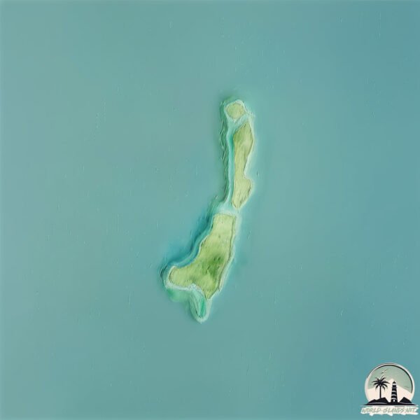
Geography and size of Kyungyi
Size: 2.198 km²
Coastline: 12.2 km
Ocean: Indian Ocean
Sea: Andaman or Burma Sea
Continent: Asia
Kyungyi is a Small Island spanning 2.2 km² with a coastline of 12.2 km.
Archipel: –
Tectonic Plate: Sunda – Extends across Southeast Asia, encompassing parts of the Sunda Shelf, known for its interaction with the Australian Plate, contributing to volcanic activity in Indonesia.
The geographic heart of the island is pinpointed at these coordinates:
Latitude: 15.07548379 / Longitude: 97.73625807
Climate and weather of Kyungyi
Climate Zone: Tropical
Climate Details: Tropical Monsoon Climate
Temperature: Hot
Climate Characteristics: Characterized by heavy rainfall, high humidity, and uniformly high temperatures, but with a distinct short dry season. It features a seasonal reversal of prevailing wind directions.
Topography and nature of Kyungyi
Timezone: UTC+06:30
Timezone places: Asia/Rangoon
Max. Elevation: -3 m
Mean Elevation: -3 m
Vegetation: Open Woodland
Tree Coverage: 9%
The mean elevation is -3 m. Remarkably, this unique island barely emerges above the sea level, showcasing nature’s fascinating interplay with the ocean. The island is characterized by Plains: Flat, low-lying lands characterized by a maximum elevation of up to 200 meters. On islands, plains are typically coastal lowlands or central flat areas.
Dominating Vegetation: Open Woodland
Characterized by sparsely distributed trees with open canopy allowing sunlight to penetrate, supporting grasses and shrubs underneath. Often found in drier or transitional environments. Kyungyi has a tree cover of 9 %.
Vegetation: 3 vegetation zones – Moderately Diverse Island
These islands start to show a broader range of ecological niches. With three vegetation zones, they may offer a mix of ecosystems like coastal areas, inland woods, and perhaps a distinct wetland or dry area. This diversity supports a wider range of flora and fauna, making these islands more ecologically complex than those with minimal diversity.
Infrastructure and Travelling to Kyungyi
Does the island have a public airport? no.
There is no public and scheduled airport on Kyungyi. The nearest airport is Dawei Airport, located 118 km away.
Does the island have a major port? no.
There are no major ports on Kyungyi. The closest major port is MOULMEIN HARBOR, approximately 155 km away.
The mean population of Kyungyi is 26 per km². Kyungyi is Gently Populated. The island belongs to Myanmar.
Continuing your journey, North is the next notable island, situated merely km away.
ကျွန်းကြီးကျွန်း ရဲ့ သဘာဝ အလှများ ဗီုပြင် ကအ်ဇ နော် ကျေဝ်ဂေါဝ်လောန်


Myanmar is classified as Least developed region: Countries that exhibit the lowest indicators of socioeconomic development, with the lowest Human Development Index ratings. The level of income is Low income.
News – Latest Updates and Headlines from Kyungyi
Stay informed with the most recent news and important headlines from Kyungyi. Here’s a roundup of the latest developments.
Please note: The data used here has been primarily extracted from satellite readings. Deviations from exact values may occur, particularly regarding the height of elevations and population density. Land area and coastline measurements refer to average values at mean high tide.