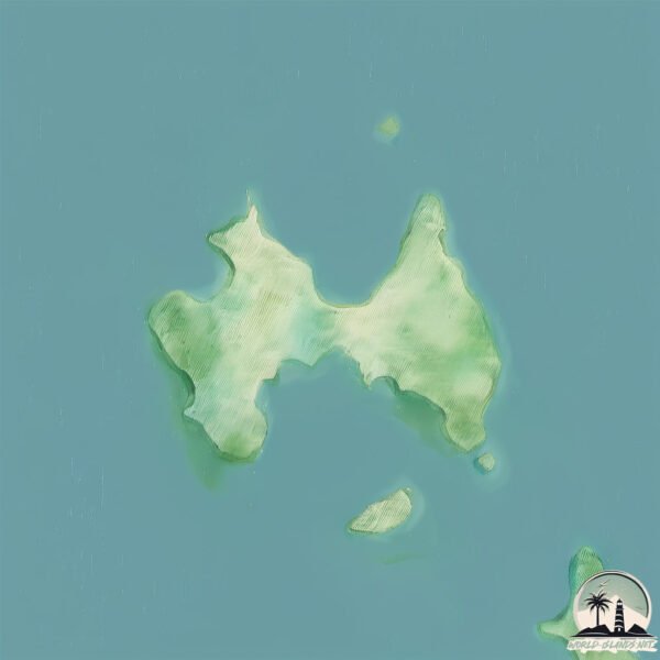
Welcome to Laeale, a Tropical island in the Andaman or Burma Sea, part of the majestic Indian Ocean. This guide offers a comprehensive overview of what makes Laeale unique – from its geography and climate to its population, infrastructure, and beyond. Dive into the details:
Geography and size of Laeale
Size: 3.372 km²
Coastline: 13.2 km
Ocean: Indian Ocean
Sea: Andaman or Burma Sea
Continent: Asia
Laeale is a Small Island spanning 3.4 km² with a coastline of 13.2 km.
Archipel: Mergui Archipelago – Located in the Andaman Sea off the coast of Myanmar, known for their pristine beaches, diverse marine life, and Moken sea nomads.
Tectonic Plate: Sunda – Extends across Southeast Asia, encompassing parts of the Sunda Shelf, known for its interaction with the Australian Plate, contributing to volcanic activity in Indonesia.
The geographic heart of the island is pinpointed at these coordinates:
Latitude: 12.36840245 / Longitude: 98.22286738
Climate and weather of Laeale
Climate Zone: Tropical
Climate Details: Tropical Monsoon Climate
Temperature: Hot
Climate Characteristics: Characterized by heavy rainfall, high humidity, and uniformly high temperatures, but with a distinct short dry season. It features a seasonal reversal of prevailing wind directions.
Topography and nature of Laeale
Timezone: UTC+06:30
Timezone places: Asia/Rangoon
Max. Elevation: 39 m
Mean Elevation: 31 m
Vegetation: Evergreen Broadleaf Forest
Tree Coverage: 85%
The mean elevation is 31 m. The highest elevation on the island reaches approximately 39 meters above sea level. The island is characterized by Plains: Flat, low-lying lands characterized by a maximum elevation of up to 200 meters. On islands, plains are typically coastal lowlands or central flat areas.
Dominating Vegetation: Evergreen Broadleaf Forest
Characterized by dense, lush canopies of broadleaf trees that retain their leaves year-round. These forests are typically found in tropical and subtropical regions and are known for their high biodiversity. Laeale has a tree cover of 85 %.
Vegetation: 5 vegetation zones – Highly Diverse Island
With five different vegetation zones, these islands offer a rich tapestry of ecosystems. The variety could include dense forests, open meadows, wetlands, coastal zones, and more. This level of diversity supports an intricate web of life, with each zone playing a vital role in the overall ecological health and balance of the island.
Infrastructure and Travelling to Laeale
Does the island have a public airport? no.
There is no public and scheduled airport on Laeale. The nearest airport is Myeik Airport, located 43 km away.
Does the island have a major port? no.
There are no major ports on Laeale. The closest major port is MERGUI, approximately 41 km away.
The mean population of Laeale is 42 per km². Laeale is Gently Populated. The island belongs to Myanmar.
Continuing your journey, Grants is the next notable island, situated merely km away.
EFTALIA ISLAND 2025 Review: Is This All-Inclusive Paradise WORTH IT?
We visited Eftalia Blue, Alanya, Antalya, Turkey on 27th Sept to 6th Oct 2025. We are a family of 5 (Nan, Mum, Dad & 2 kids aged ...EFTALIA ISLAND 2025 Review: Is This All-Inclusive Paradise WORTH IT?
We visited Eftalia Blue, Alanya, Antalya, Turkey on 27th Sept to 6th ...
We visited Eftalia Blue, Alanya, Antalya, Turkey on 27th Sept to 6th Oct 2025. We are a family of 5 (Nan, Mum, Dad & 2 kids aged ...
I visited America’s most remote island (Adak, AK)
A Place Where Time Stands Still: Aleutian Islands
Thank you so much for joining me on this adventure. Please don't ...
Thank you so much for joining me on this adventure. Please don't forget to like this video, and subscribe to my YouTube channel, ...
Eftalia Island Walkthrough Tour Summer 2025
Music Reference ––––––––––––––––––––––––––––– Music: like a dream by ...
Music Reference ––––––––––––––––––––––––––––– Music: like a dream by Øraeth / itsoraeth License: Creative Commons ...
Eftalia Island
The largest beach and entertainment area in the Mediterranean region, ...
The largest beach and entertainment area in the Mediterranean region, within Eftalia Hotels.
Eftalia Island #allinclusive #allinclusivehotel #alanya #eftalia #eftaliahotels #eftaliaisland
Burgerland at Eftalia Aqua #burger #burgerland #allinclusive #allinclusiveresort #eftaliaaqua
Umnak - Aleutian Islands
40 day long trip across the Umnak Island The Aleutian Islands are an ...
40 day long trip across the Umnak Island The Aleutian Islands are an archipelago of 110 volcanic islands in the North Pacific ...
Adak: Why the Westernmost Town in the US Exists
Sign up for a CuriosityStream subscription and also get a free Nebula ...
Sign up for a CuriosityStream subscription and also get a free Nebula subscription (the streaming platform built by creators) here: ...
Life on a REMOTE ALASKAN ISLAND in the North Pacific (Exploring Unalaska & Dutch Harbor, Alaska)
Unalaska Island (formerly known as Dutch Harbor) is about as far from ...
Unalaska Island (formerly known as Dutch Harbor) is about as far from big city America as you can get. Nestled in the heart of the ...
A day in Unalaska, Alaska | Remote Alaska, Aleutian Islands
Join me on a trip to the quiet beauty of Unalaska, Alaska — one of the ...
Join me on a trip to the quiet beauty of Unalaska, Alaska — one of the most remote and captivating towns in the United States.
Venture to the Aleutians. Complete Trip 2015
This journey has been uploaded on You Tube for some time in a series ...
This journey has been uploaded on You Tube for some time in a series of short videos. This has apparently caused some ...
A Surf Trip to a Remote Island in Alaska's Deadly Bering Sea
"Return to the Bering" is the sequel to the award winning "Island X", ...
"Return to the Bering" is the sequel to the award winning "Island X", taking surfers Noah Wegrich, Pete Devries, Mark McInnis and ...
How many People LIVE in the Aleutian Islands? #distantelephant #alaska #geography #maps #islands
Alaska summer never gets dark 😓 #travelalaska #youtubeshorts #subscribe #alaska #viral
The food court down on the island! #allinclusive #alanya #turkiye #eftalia #holiday #Eftalia island
The Only Land Battle Fought on U.S. soil in WWII (Strange Stories)
Become a Simple History member: ...
Japanese Invasion of Alaska - Pacific War DOCUMENTARY
Get 20% OFF + Free International Shipping @Manscaped with code K&G or ...
The Alaskan Archipelago With An Unforgiving Climate | The Aleutians: Cradle Of The Storms
At the northern edge of the Pacific Ocean lies an island chain with a ...
At the northern edge of the Pacific Ocean lies an island chain with a stormy and turbulent history. The Aleutian Islands are the ...
Life on Alaska's Most Remote Island (surreal experience) 🇺🇸
Far from the Alaskan mainland is a secluded island in the Bering ...
Far from the Alaskan mainland is a secluded island in the Bering Strait. Here the views span for an eternity, Russia is within sight, ...
Aleutian Island Discovery of 1940 #giants #discovery #nephilim #shots #shortvideo #truehistory
The shadows of real giants loom throughout mythology and folklore. ...
The shadows of real giants loom throughout mythology and folklore. Almost every culture and society nourishes its tales of huge ...
Forgotten Battle of the Aleutian Islands | Alaska at War | WW2 Documentary in Color | 1943
This US state defies convention...literally
"Think you know everything about Alaska? Think again! Did you know ...
"Think you know everything about Alaska? Think again! Did you know that this vast state isn't just the westernmost in the U.S., but ...
Myanmar is classified as Least developed region: Countries that exhibit the lowest indicators of socioeconomic development, with the lowest Human Development Index ratings. The level of income is Low income.
News – Latest Updates and Headlines from Laeale
Stay informed with the most recent news and important headlines from Laeale. Here’s a roundup of the latest developments.
Loading...
Please note: The data used here has been primarily extracted from satellite readings. Deviations from exact values may occur, particularly regarding the height of elevations and population density. Land area and coastline measurements refer to average values at mean high tide.