Welcome to Macleod, a Tropical island in the Andaman or Burma Sea, part of the majestic Indian Ocean. This guide offers a comprehensive overview of what makes Macleod unique – from its geography and climate to its population, infrastructure, and beyond. Dive into the details:
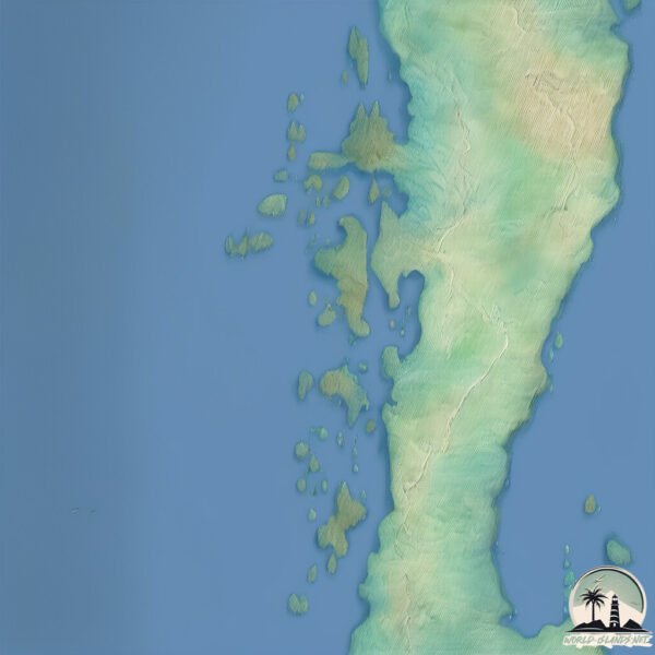
Geography and size of Macleod
Size: 7.957 km²
Coastline: 22.3 km
Ocean: Indian Ocean
Sea: Andaman or Burma Sea
Continent: Asia
Macleod is a Small Island spanning 8 km² with a coastline of 22.3 km.
Archipel: Mergui Archipelago – Located in the Andaman Sea off the coast of Myanmar, known for their pristine beaches, diverse marine life, and Moken sea nomads.
Tectonic Plate: Sunda – Extends across Southeast Asia, encompassing parts of the Sunda Shelf, known for its interaction with the Australian Plate, contributing to volcanic activity in Indonesia.
The geographic heart of the island is pinpointed at these coordinates:
Latitude: 11.44460533 / Longitude: 98.0729101
Climate and weather of Macleod
Climate Zone: Tropical
Climate Details: Tropical Monsoon Climate
Temperature: Hot
Climate Characteristics: Characterized by heavy rainfall, high humidity, and uniformly high temperatures, but with a distinct short dry season. It features a seasonal reversal of prevailing wind directions.
Topography and nature of Macleod
Timezone: UTC+06:30
Timezone places: Asia/Rangoon
Max. Elevation: 160 m
Mean Elevation: 59 m
Vegetation: Evergreen Broadleaf Forest
Tree Coverage: 90%
The mean elevation is 59 m. The highest elevation on the island reaches approximately 160 meters above sea level. The island is characterized by Plains: Flat, low-lying lands characterized by a maximum elevation of up to 200 meters. On islands, plains are typically coastal lowlands or central flat areas.
Dominating Vegetation: Evergreen Broadleaf Forest
Characterized by dense, lush canopies of broadleaf trees that retain their leaves year-round. These forests are typically found in tropical and subtropical regions and are known for their high biodiversity. Macleod has a tree cover of 90 %.
Vegetation: 6 vegetation zones – Very Highly Diverse Island
Islands in this range are ecological powerhouses, showcasing a wide array of vegetation zones. Each zone, from lush rainforests to arid scrublands, coastal mangroves to mountainous regions, contributes to a complex and interdependent ecosystem. These islands are often hotspots of biodiversity, supporting numerous species and intricate ecological processes.
Infrastructure and Travelling to Macleod
Does the island have a public airport? no.
There is no public and scheduled airport on Macleod. The nearest airport is Myeik Airport, located 50 km away.
Does the island have a major port? no.
There are no major ports on Macleod. The closest major port is MERGUI, approximately 48 km away.
The mean population of Macleod is 61 per km². Macleod is Gently Populated. The island belongs to Myanmar.
Continuing your journey, Grants is the next notable island, situated merely km away.
MacLeod Island 🏝️🏖️ in Myanmar
MacLeod Island 🏝️🏖️ in Myanmar
Exploring the Mysteries of Macleod Island
Discover the uninhabited beauty of Macleod Island, highlighting its ...
Discover the uninhabited beauty of Macleod Island, highlighting its unique features and survival insights. #MacleodIsland ...
Star Cruises Trip to Phuket & MacLeod Island (Myanmar)! #TCTravel
If you've liked this video, remember to LIKE and SHARE it around! It ...
If you've liked this video, remember to LIKE and SHARE it around! It helps a lot! =D Subscribe for more videos. For more info about ...
{NOIR} TRIP - Macleod Island Part 1 - The Journey
The pilot episode of {NOIR} TRIP takes you to the Macleod Island, ...
The pilot episode of {NOIR} TRIP takes you to the Macleod Island, Myanmar. We'll show you how to get there and how's the resort.
Macleod Island@Myanmar
Trip Reindeer Beach เกาะ Macleod Island @Myanmar เมื่อวันที่ ...
Trip Reindeer Beach เกาะ Macleod Island @Myanmar เมื่อวันที่ 17.02.2019 By ไกด์ขมิ้น เดินทางไปกับ Anadaman Duck @ระนอง ...
Macleod Island Myanmar , Burma
Myanmar Andaman Resort is so far the only resort in the Mergui ...
Myanmar Andaman Resort is so far the only resort in the Mergui Archipelago, well hidden in at the beach of Macleod Island.
Macleod Island - Myanmar
This is the Macleod Island in Myanmar 🏝️ The crystal-clear waters, ...
This is the Macleod Island in Myanmar 🏝️ The crystal-clear waters, vibrant coral reefs, and lush greenery make it a paradise for ...
Macleod Island Scotch Whisky
Bottle Review No.144 #whiskey #whiskytubefamily #blendedscotch ...
Bottle Review No.144 #whiskey #whiskytubefamily #blendedscotch #whiskey #whiskeyadvice #bourbon #blendedmalt ...
Macleod Island Kawthaung, Myanmar.#amazing #beach
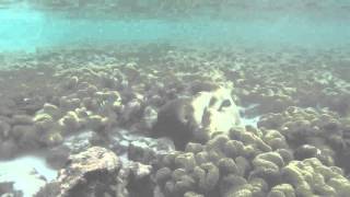
Macleod island is fringed by and abundance of rainforests and coral ...
Macleod island is fringed by and abundance of rainforests and coral reefs. Sparkles blue water and white beach will greet warmly ...
Macleod Island | Myanmar | The Destination | Travel Enjoy
Macleod Island Myanmar , Burma
Enjoy Surfing, Scuba Diving, short trekking and snorkelling at ...
Enjoy Surfing, Scuba Diving, short trekking and snorkelling at #Macleod_Island, #Mergui_Archipelago at #Myanmar. One can ...
{NOIR} TRIP - Macleod Island Part 2 - Into The Blue
This episode take you to explore the the blue world around Macleod ...
This episode take you to explore the the blue world around Macleod Island, Myanmar and stunning landscape. Official Facebook ...
Beautiful Macleod Island (Myanmar)
Beautiful Macleod Island (Myanmar)
Beautiful Macleod Island (Myanmar)
A Visit to MacLeod Island
Rambling on Macleod Island - Myanmar
Musicepicure exploring Macleod Island in Andaman Sea Myanmar (Burma)
Musicepicure exploring Macleod Island in Andaman Sea Myanmar (Burma)
A visit to Macleod island
Macleod island is situated in Myanmar It is an island that most of the ...
Macleod island is situated in Myanmar It is an island that most of the locals don't even know or heard about it Have you been there ...
Diving Macleod Island part 1
Enjoy the underwaterworld around Macleod island Myanmar.
Enjoy the underwaterworld around Macleod island Myanmar.
{NOIR} TRIP - Macleod Island Part 3 - The Mountain Top
This episode takes you to the mountain top of Macleod Island. The ...
This episode takes you to the mountain top of Macleod Island. The landscape is so stunning. You should see it by yourself. Official ...
Diving Macleod Island Videos 1
Enjoy the underwaterworld around Macleod Island Myanmar.
Enjoy the underwaterworld around Macleod Island Myanmar.
MacLeod Island @ Kaw Thaung
Video Macleod island , Myanmar, Andaman resort
arriving at macleod island Myanmar. Myanmar Andaman Resort is the only ...
arriving at macleod island Myanmar. Myanmar Andaman Resort is the only resort on Macleod Island in the Mergui Archipelago.
Diving Macleod Island part 2
Enjoy the underwaterworld around Macleod island Myanmar.
Enjoy the underwaterworld around Macleod island Myanmar.
Shallow wafer coral and marine life at Macleod / Maeleod island / Myanmar Andaman Resort
Paddled out to the outer fork of Macleod island and explored the ...
Paddled out to the outer fork of Macleod island and explored the shallow wafer coral and marine life with GoPro.
Macleod Island Myanmar Birma
Myanmar Andaman Resort is the only resort on Macleod Island in the ...
Myanmar Andaman Resort is the only resort on Macleod Island in the Mergui Archipelago. It should be underlined that it is more ...
Macleod Island , Myanmar 緬甸麥克勞德島
5 Nov 2017 麗星郵輪首航緬甸麥克勞德島,揭開神秘的丹老群島(Mergui Archipelago)。 ...
5 Nov 2017 麗星郵輪首航緬甸麥克勞德島,揭開神秘的丹老群島(Mergui Archipelago)。 搭乘天秤星號從馬來西亞巴生港口出發, ...
Myanmar is classified as Least developed region: Countries that exhibit the lowest indicators of socioeconomic development, with the lowest Human Development Index ratings. The level of income is Low income.
News – Latest Updates and Headlines from Macleod
Stay informed with the most recent news and important headlines from Macleod. Here’s a roundup of the latest developments.
Loading...
Please note: The data used here has been primarily extracted from satellite readings. Deviations from exact values may occur, particularly regarding the height of elevations and population density. Land area and coastline measurements refer to average values at mean high tide.