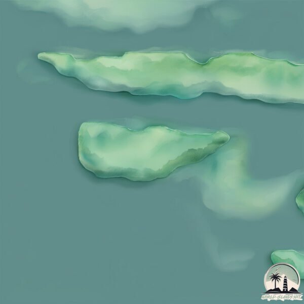
Welcome to Miehiluoto, a Continental island in the Gulf of Bothnia, part of the majestic Atlantic Ocean. This guide offers a comprehensive overview of what makes Miehiluoto unique – from its geography and climate to its population, infrastructure, and beyond. Dive into the details:
Geography and size of Miehiluoto
Size: 0.172 km²
Coastline: 1.8 km
Ocean: Atlantic Ocean
Sea: Gulf of Bothnia
Continent: Europe
Miehiluoto is a Tiny Island spanning 0.172 km² with a coastline of 1.8 km.
Archipel: –
Tectonic Plate: Eurasia – One of the world’s largest tectonic plates, the Eurasian Plate covers a significant portion of Europe and Asia. It’s characterized by diverse geological features, including the Ural Mountains, the European Plain, and the Himalayas formed from its collision with the Indian Plate.
The geographic heart of the island is pinpointed at these coordinates:
Latitude: 60.33361345 / Longitude: 21.85295368
Climate and weather of Miehiluoto
Climate Zone: Continental
Climate Details: Warm-Summer Humid Continental Climate
Temperature: Warm Summer
Climate Characteristics: Features warm summers and cold winters with consistent precipitation, common in higher latitudes.
Topography and nature of Miehiluoto
Timezone: UTC+02:00
Timezone places: Europe/Helsinki
Max. Elevation: 27 m
Mean Elevation: 24 m
Vegetation: Evergreen Needleleaf Forest
Tree Coverage: 0%
The mean elevation is 24 m. The highest elevation on the island reaches approximately 27 meters above sea level. The island is characterized by Plains: Flat, low-lying lands characterized by a maximum elevation of up to 200 meters. On islands, plains are typically coastal lowlands or central flat areas.
Dominating Vegetation: Evergreen Needleleaf Forest
Dominated by evergreen coniferous trees such as pines and firs, which retain their needle-like leaves throughout the year. These forests are often found in cooler climates. Miehiluoto has a tree cover of 0 %.
Vegetation: 2 vegetation zones – Low Diversity Island
Islands with two distinct vegetation zones offer slightly more ecological variety. These zones could be due to differences in elevation, moisture, or other environmental factors. While still limited in biodiversity, these islands may offer a contrast between the two zones, such as a coastline with mangroves and an inland area with grassland.
Infrastructure and Travelling to Miehiluoto
Does the island have a public airport? no.
There is no public and scheduled airport on Miehiluoto. The nearest airport is Turku Airport, located 49 km away.
Does the island have a major port? no.
There are no major ports on Miehiluoto. The closest major port is NAANTALI, approximately 23 km away.
The mean population of Miehiluoto is 62 per km². Miehiluoto is Gently Populated. The island belongs to Finland.
Continuing your journey, Aaslaluoto is the next notable island, situated merely km away.
MITIARO, COOK ISLANDS: Island hopping from Rarotonga to a remote POPULATION OF 164!
Have you ever imagined remote living in a small tropical island community?! Mitiaro has the smallest population of any of the ...MITIARO, COOK ISLANDS: Island hopping from Rarotonga to a remote POPULATION OF 164!
Have you ever imagined remote living in a small tropical island ...
Have you ever imagined remote living in a small tropical island community?! Mitiaro has the smallest population of any of the ...
Mitiaro Unveiled: Discover the Cook Islands' Best-Kept Secret for an Exotic Escape
Mitiaro stands as a beacon of serene beauty and intriguing contrasts ...
Mitiaro stands as a beacon of serene beauty and intriguing contrasts in the Pacific's heart. This enchanting island, a lesser-known ...
Japan's Forgotten Paradise: The Natural Wonders of Iriomote | 4K UHD Documentary
"Iriomote - The Fabric of Life" explores one of Japan's most ...
"Iriomote - The Fabric of Life" explores one of Japan's most captivating and untamed islands. Nestled in the East China Sea, ...
Mauke: A Tranquil Paradise Amidst the Wild Beauty of the Cook Islands
"What Makes Mauke An Awesome Place? Finding Your Paradise Destiny" is ...
"What Makes Mauke An Awesome Place? Finding Your Paradise Destiny" is a captivating video that takes you on a journey to the ...
OKINAWA 🇯🇵 JAPAN'S HIDDEN GEM (IRIOMOTE)
What to see in Mitiaro | The Cook Islands
Harbouring some of the most stunning subterranean limestone caves and ...
Harbouring some of the most stunning subterranean limestone caves and pools to be found in the Pacific, Mitiaro is a natural ...
The Ultimate Ishigaki Island Travel Guide | Tokyo Weekender
We needed some time out from the hustle and bustle of Tokyo, so we ...
We needed some time out from the hustle and bustle of Tokyo, so we took a short flight down to Ishigaki Island (and neighboring ...
Mitiaro Island Vai Tamaroa cave diving!
On the Island of Mitiaro, there are a maze of underground caves that ...
On the Island of Mitiaro, there are a maze of underground caves that provide water for much of the island and are fun to explore!
Inside Iriomote National Park: Japan’s Wildlife Sanctuary | Full Documentary
Japan's southernmost island: Iriomote. This Eden is covered by ...
Japan's southernmost island: Iriomote. This Eden is covered by tropical forests, the shoreline protected by mangroves. Some of ...
Mitiaro, Cook Islands
Harbouring some of the most stunning subterranean limestone caves and ...
Harbouring some of the most stunning subterranean limestone caves and pools to be found in the Pacific, Mitiaro is a natural ...
Visit the Cook Islands - Mitiaro Homestay
Come and explore the Cook Islands with me.
Come and explore the Cook Islands with me.
Inside Japan's Most Tropical Resort! | The Iriomote Hotel by Hoshino Resorts
Cook Island Dance - Mitiaro 1995
Found this on and old VHS tape from our trip to the Cook Islands in 1995.
Found this on and old VHS tape from our trip to the Cook Islands in 1995.
Iriomote Island: Japan’s Wild Subtropical Gem 🌿🐾
Explore Iriomote Island, a lush paradise in Japan's Yaeyama Islands. ...
Explore Iriomote Island, a lush paradise in Japan's Yaeyama Islands. Covered in dense jungles and mangrove forests, this ...
A Beginner’s Guide To Okinawa, Japan
Okinawa isn't your average Japan trip, it's sun, sea, history, and ...
Okinawa isn't your average Japan trip, it's sun, sea, history, and island soul rolled into one. Between US military bases, ancient ...
COOK ISLANDS: EXPLORING AITUTAKI (Arutanga and Araura Villages).
One of the best things about slowing down to the pace of island life ...
One of the best things about slowing down to the pace of island life means that laid back days seem to just naturally evolve into ...
A disappointing day on Iriomote // how to get around Iriomote (without failing)
Hey guys...this was a rough day. We totally failed at getting around ...
Hey guys...this was a rough day. We totally failed at getting around Iriomote, so I wanted to make this video to show you that it's ...
Iriomote Island - Japan's most UNTOUCHED Jungle Island Paradise
After Surviving the Typhoon in Ishigaki we take the ferry to ...
After Surviving the Typhoon in Ishigaki we take the ferry to Iriomote.Iriomote Island is one of the remotest Yaeyama Islands in ...
Miyakojima. The Remote Island Where People Live Longest On Earth (Okinawa, Japan)
Come to Miyakojima or Miyako Island in Okinawa Japan with me, to ...
Come to Miyakojima or Miyako Island in Okinawa Japan with me, to uncover the world's most beautiful pristine and underrated ...
254 Beaches in Iriomote Island in Okinawa Prefecture / Travels of Scenic Japan / Tabiator
The beaches facing the shallow sea surrounded by reefs in Okinawa ...
The beaches facing the shallow sea surrounded by reefs in Okinawa Prefecture. Iriomote Island, with a circumference of 130 km, ...
A tiny dot of magic in the pacific - the Cook Islands 🌴 #cookislands #paradise #polynesia
【旅エイター ★ 2154】Beaches in Iriomote Island [Travels of Scenic Japan by Tabiator]
The beaches facing the shallow sea surrounded by reefs in Okinawa ...
The beaches facing the shallow sea surrounded by reefs in Okinawa Prefecture. Iriomote Island, with a circumference of 130 km, ...
Cook Islands highlights in 10 seconds 🏖️ #cookislands #aitutaki #rarotonga #travel
【Okinawa 】iriomote island‼︎#gopro #diving #travel #okinawa
Fishing Madagascar Pt.1 - Heading to Mitsio Archipelago and a CRAZY first day on the water!
In this new series join Kieren as he embarks on one of his hosted ...
In this new series join Kieren as he embarks on one of his hosted fishing trips to the Archipelago of Mitsio - Madagascar.
Finland is classified as Developed region: nonG7: Developed economies outside of the Group of Seven, characterized by high income and advanced economic structures. The level of income is High income: OECD.
News – Latest Updates and Headlines from Miehiluoto
Stay informed with the most recent news and important headlines from Miehiluoto. Here’s a roundup of the latest developments.
Loading...
Please note: The data used here has been primarily extracted from satellite readings. Deviations from exact values may occur, particularly regarding the height of elevations and population density. Land area and coastline measurements refer to average values at mean high tide.


![【旅エイター ★ 2154】Beaches in Iriomote Island [Travels of Scenic Japan by Tabiator]](https://i.ytimg.com/vi/kWoZqCSIkcg/mqdefault.jpg)


