Welcome to Narr Kho, a Tropical island in the Andaman or Burma Sea, part of the majestic Indian Ocean. This guide offers a comprehensive overview of what makes Narr Kho unique – from its geography and climate to its population, infrastructure, and beyond. Dive into the details:
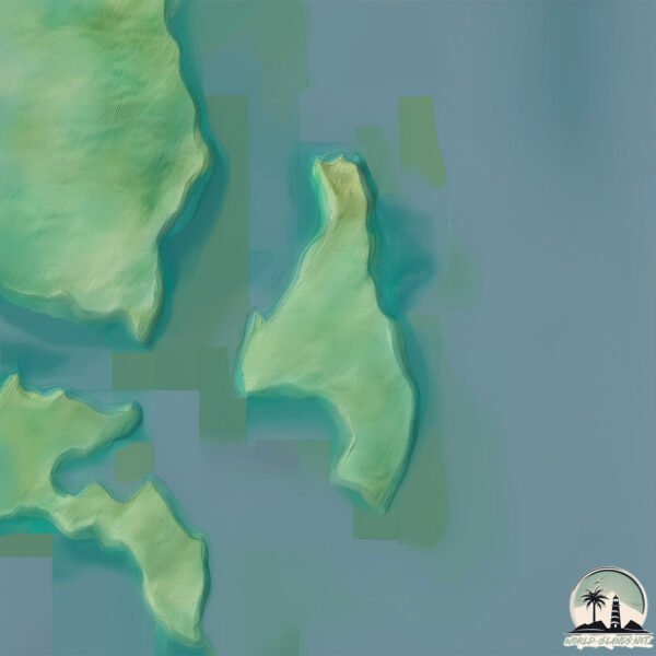
Geography and size of Narr Kho
Size: 2.281 km²
Coastline: 9.2 km
Ocean: Indian Ocean
Sea: Andaman or Burma Sea
Continent: Asia
Narr Kho is a Small Island spanning 2.3 km² with a coastline of 9.2 km.
Archipel: Mergui Archipelago – Located in the Andaman Sea off the coast of Myanmar, known for their pristine beaches, diverse marine life, and Moken sea nomads.
Tectonic Plate: Sunda – Extends across Southeast Asia, encompassing parts of the Sunda Shelf, known for its interaction with the Australian Plate, contributing to volcanic activity in Indonesia.
The geographic heart of the island is pinpointed at these coordinates:
Latitude: 10.42519029 / Longitude: 97.95770943
Climate and weather of Narr Kho
Climate Zone: Tropical
Climate Details: Tropical Monsoon Climate
Temperature: Hot
Climate Characteristics: Characterized by heavy rainfall, high humidity, and uniformly high temperatures, but with a distinct short dry season. It features a seasonal reversal of prevailing wind directions.
Topography and nature of Narr Kho
Timezone: UTC+06:30
Timezone places: Asia/Rangoon
Max. Elevation: 61 m
Mean Elevation: 52 m
Vegetation: Evergreen Broadleaf Forest
Tree Coverage: 86%
The mean elevation is 52 m. The highest elevation on the island reaches approximately 61 meters above sea level. The island is characterized by Plains: Flat, low-lying lands characterized by a maximum elevation of up to 200 meters. On islands, plains are typically coastal lowlands or central flat areas.
Dominating Vegetation: Evergreen Broadleaf Forest
Characterized by dense, lush canopies of broadleaf trees that retain their leaves year-round. These forests are typically found in tropical and subtropical regions and are known for their high biodiversity. Narr Kho has a tree cover of 86 %.
Vegetation: 4 vegetation zones – Diverse Island
Four distinct vegetation zones mark these islands as ecologically diverse. They might feature varied landscapes such as forests, beaches, grasslands, and rocky areas. Such diversity reflects the island’s complex ecological interactions and varied habitats, which can support a rich array of wildlife and plant species.
Infrastructure and Travelling to Narr Kho
Does the island have a public airport? no.
There is no public and scheduled airport on Narr Kho. The nearest airport is Kawthoung Airport, located 76 km away.
Does the island have a major port? no.
There are no major ports on Narr Kho. The closest major port is BANG SAPHAN, approximately 200 km away.
The mean population of Narr Kho is 83 per km². Narr Kho is Gently Populated. The island belongs to Myanmar.
Continuing your journey, Lord Loughborough is the next notable island, situated merely km away.
What is happening on Death Island?
With over 24 mysterious deaths recorded on the island of Koh Tao, a dark history lurks behind tropical paradise... So much, that it ...What is happening on Death Island?
With over 24 mysterious deaths recorded on the island of Koh Tao, a ...
With over 24 mysterious deaths recorded on the island of Koh Tao, a dark history lurks behind tropical paradise... So much, that it ...
How Koh Tao became Thailand's 'Death Island'|Koh Tao Murders
The Koh Tao Murders | True Crime Documentary
The Koh Tao murders involved Hannah Witheridge and David Miller, who ...
The Koh Tao murders involved Hannah Witheridge and David Miller, who were found on Sairee Beach in Koh Tao. The crime ...
"Ajnabee Island Par Kho Gaya Aadmi | Mysterious Island Survival Story | Movie Explained in English"
In this gripping video, we dive deep into the mysterious and ...
In this gripping video, we dive deep into the mysterious and heart-pounding story of a man who gets lost on a strange and ...
World’s Most Dangerous Island | Koh Tao • Desi Crime
Summer is here and the heat is setting us all ablaze. Sweltering ...
Summer is here and the heat is setting us all ablaze. Sweltering temperatures across the world make us all want to run away to an ...
#OakIsland: An #UnsolvedMystery... #history #pirates
Did pirates bury a massive treasure on Oak Island? Maybe. Maybe not.
Did pirates bury a massive treasure on Oak Island? Maybe. Maybe not.
Death by Dig: The Horrifying History of Oak Island's Curse #OakIslandCurse #unexplained #truestory
Oak Island. A solitary speck of land shrouded in fog and whispered ...
Oak Island. A solitary speck of land shrouded in fog and whispered legends. For centuries, treasure hunters have been drawn to ...
Oak Island Mystery Solved
The Oak Island treasure's origins trace back to the Knights Templar, ...
The Oak Island treasure's origins trace back to the Knights Templar, whose ideological descendants transported gold, silver, ...
‘My money builds your country’: Israeli tourist apologises after Thai backlash
'My money builds your country': Israeli tourist apologises after Thai ...
'My money builds your country': Israeli tourist apologises after Thai backlash . A viral incident involving an Israeli tourist has ...
La Classe Ouvrière : 300 ans de luttes et de révolutions - Documentaire Histoire - AT
Trois siècles de luttes ont façonné notre monde moderne. + de ...
Trois siècles de luttes ont façonné notre monde moderne. + de documentaires histoire
http://bit.ly/3lqyFpY Abonnez vous !
The Best Preserved Castle Isn't Where You Think
The Isle of Man, nestled in the Irish Sea between England, Ireland, ...
The Isle of Man, nestled in the Irish Sea between England, Ireland, Scotland, and Wales, holds a unique vantage point that has ...
1999 - Treasure Island - Starring Jack Palance - Inspired by the R. L. Stevenson story
X marks the spot for treachery and adventure in this high-seas hunt ...
X marks the spot for treachery and adventure in this high-seas hunt for hidden gold! Young Jim Hawkins discovers a map to ...
The Lost Treasure of the Llanganatis
Embark on an expedition to uncover the fabled lost treasure of the ...
Embark on an expedition to uncover the fabled lost treasure of the Llanganatis mountains in Ecuador. Legends speak of hidden ...
यह Skydiver लड़की नीचे कैसे उतरती है 🤔
The content presented in this video is intended for EDUCATIONAL ...
The content presented in this video is intended for EDUCATIONAL PURPOSES only No one hurt in this Disclaimer : No one was ...
The Oak Island Money Pit: Curse or Hidden Treasure? #treasurehunting #history #facts
For over 200 years, treasure hunters have been captivated by the Oak ...
For over 200 years, treasure hunters have been captivated by the Oak Island Money Pit, a mysterious site believed to hide an ...
How the money pit killed the man
How the money pit killed the man Uncover a tragic tale in our YouTube ...
How the money pit killed the man Uncover a tragic tale in our YouTube Shorts, 'How a Money Pit Killed a Man.' Journey back to ...
The Curse of Oak Island
The Curse of Oak Island is a captivating exploration into one of the ...
The Curse of Oak Island is a captivating exploration into one of the world's most baffling enigmas. Join us as we delve deep into ...
Poveglia – वो मोहब्बत जो वक़्त से परे थी Haunted Love Story from Italy
Kya aapne kabhi kisi se aisa pyaar kiya hai… jo waqt, jagah… aur maut ...
Kya aapne kabhi kisi se aisa pyaar kiya hai… jo waqt, jagah… aur maut se bhi aage nikal jaye? Poveglia Island – Venice, Italy Ek ...
Save the Sea Queen | ANIMATION | Full Movie in English 💎
A magic artifact transports three boys to the 18th century, where they ...
A magic artifact transports three boys to the 18th century, where they meet pirates Blackbeard and the Sea Queen. Genre : Family ...
Doodling My Day 😍 #shortsfeed #shortsvideo #doodle #drawing #doodleart #tutorialtamil
shortsfeed #shortsvideo #doodle #drawing #doodleart #tutorialtamil ...
shortsfeed #shortsvideo #doodle #drawing #doodleart #tutorialtamil #painting #oilpasteldrawing #doodleartdrawing ...
熱血抗戰《血戰到底之壯丁也是兵》17丨背負 「叛國」 污名的川軍營長趙國武,集結底層百姓組成壯丁團抗日,譜寫出了可歌可泣的戰爭史詩!#抗日戰爭 #戰爭 #奇道 #徐翠翠 #陳創 #姜寒 #斌子 #王迅
正版授權,歡迎訂閱! 如果你不知道如何切換字幕語言,請往下看: If you don't know how to switch ...
正版授權,歡迎訂閱! 如果你不知道如何切換字幕語言,請往下看: If you don't know how to switch subtitle languages, please ...
They DISAPPEARED! The Oak Island Money Pit's DEADLY Secret #history #youtubeshorts
They DISAPPEARED! The Oak Island Money Pit's DEADLY Secret #history ...
They DISAPPEARED! The Oak Island Money Pit's DEADLY Secret #history #youtubeshorts Oak Island. A small island off the coast ...
I Flew My Drone to a Forbidden Island | Abandoned Gould Island #dji #abandoned #ww2 #urbex
When Naruto And Kurama Became Friends 🔥 #naruto #anime
When Naruto And Kurama Became Friends #naruto #anime #animeedit #shrots.
When Naruto And Kurama Became Friends #naruto #anime #animeedit #shrots.
Abandoned Torpedo Station | Gould Island | Rhode Island #urbanexploration #abandoned #history #ww2
Myanmar is classified as Least developed region: Countries that exhibit the lowest indicators of socioeconomic development, with the lowest Human Development Index ratings. The level of income is Low income.
News – Latest Updates and Headlines from Narr Kho
Stay informed with the most recent news and important headlines from Narr Kho. Here’s a roundup of the latest developments.
Loading...
Please note: The data used here has been primarily extracted from satellite readings. Deviations from exact values may occur, particularly regarding the height of elevations and population density. Land area and coastline measurements refer to average values at mean high tide.