Welcome to Pulo Myang Basa, a Tropical island in the Andaman or Burma Sea, part of the majestic Indian Ocean. This guide offers a comprehensive overview of what makes Pulo Myang Basa unique – from its geography and climate to its population, infrastructure, and beyond. Dive into the details:
Geography and size of Pulo Myang Basa
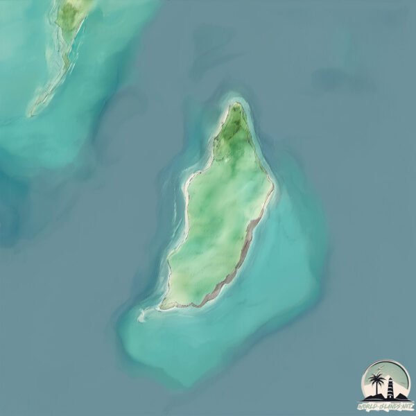
Size: 1.412 km²
Coastline: 6.2 km
Ocean: Indian Ocean
Sea: Andaman or Burma Sea
Continent: Asia
Pulo Myang Basa is a Small Island spanning 1.4 km² with a coastline of 6.2 km.
Archipel: –
Tectonic Plate: Sunda – Extends across Southeast Asia, encompassing parts of the Sunda Shelf, known for its interaction with the Australian Plate, contributing to volcanic activity in Indonesia.
The geographic heart of the island is pinpointed at these coordinates:
Latitude: 10.64228865 / Longitude: 98.35702887
Climate and weather of Pulo Myang Basa
Climate Zone: Tropical
Climate Details: Tropical Monsoon Climate
Temperature: Hot
Climate Characteristics: Characterized by heavy rainfall, high humidity, and uniformly high temperatures, but with a distinct short dry season. It features a seasonal reversal of prevailing wind directions.
Topography and nature of Pulo Myang Basa
Timezone: UTC+06:30
Timezone places: Asia/Rangoon
Max. Elevation: 19 m
Mean Elevation: 14 m
Vegetation: Evergreen Needleleaf Forest
Tree Coverage: 66%
The mean elevation is 14 m. The highest elevation on the island reaches approximately 19 meters above sea level. The island is characterized by Plains: Flat, low-lying lands characterized by a maximum elevation of up to 200 meters. On islands, plains are typically coastal lowlands or central flat areas.
Dominating Vegetation: Evergreen Needleleaf Forest
Dominated by evergreen coniferous trees such as pines and firs, which retain their needle-like leaves throughout the year. These forests are often found in cooler climates. Pulo Myang Basa has a tree cover of 66 %.
Vegetation: 3 vegetation zones – Moderately Diverse Island
These islands start to show a broader range of ecological niches. With three vegetation zones, they may offer a mix of ecosystems like coastal areas, inland woods, and perhaps a distinct wetland or dry area. This diversity supports a wider range of flora and fauna, making these islands more ecologically complex than those with minimal diversity.
Infrastructure and Travelling to Pulo Myang Basa
Does the island have a public airport? no.
There is no public and scheduled airport on Pulo Myang Basa. The nearest airport is Kawthoung Airport, located 68 km away.
Does the island have a major port? no.
There are no major ports on Pulo Myang Basa. The closest major port is BANG SAPHAN, approximately 150 km away.
The mean population of Pulo Myang Basa is 14 per km². Pulo Myang Basa is Gently Populated. The island belongs to Myanmar.
Continuing your journey, Buda is the next notable island, situated merely km away.
Cocos Island: Daerah Australia Rasa Indonesia
Cocos Island: Daerah Australia Rasa Indonesia
EPSTEIN ADASI'NA GİTTİM - EPSTEIN DOSYALARI
Epstein Adası'nın Karanlık Sırları: Oraya Gittim! Jeffrey Epstein ...
Epstein Adası'nın Karanlık Sırları: Oraya Gittim! Jeffrey Epstein kimdir ve dünyayı sarsan bu karanlık ağ nasıl kuruldu? Bill Clinton ...
Pulau Cocos: Pulau di Australia yang Banyak Dihuni Orang Jawa
Pulau Cocos merupakan pulau yang berada di sebelah selatan Indonesia, ...
Pulau Cocos merupakan pulau yang berada di sebelah selatan Indonesia, berjarak kurang lebih 1000 Km dari Jakarta. Meskipun ...
TRADISI SUKU NIAS YANG MEMUKAU MASYARAKAT INDONESIA😍❤️🇮🇩
TRADISI SUKU NIAS YANG MEMUKAU MASYARAKAT INDONESIA ❤️ #nias ...
TRADISI SUKU NIAS YANG MEMUKAU MASYARAKAT INDONESIA ❤️ #nias #hombobatu #tradisi.
From Prison to Revenge | Terence Stamp (Star Wars) | THRILLER | Full Movie in English
A furious father enters a world he doesn't understand, carving a path ...
A furious father enters a world he doesn't understand, carving a path through ruthless criminals to expose the truth and deliver his ...
Philippines map and city with famous| world map of countries|# countries map|# famous countries
world map,country map quiz,guess the country on the ...
world map,country map quiz,guess the country on the map,country,map,guess the country by map,world map with countries,guess ...
MAKHLUK PERTAMA YANG MENEMPATI PULAU JAWA
sejarah makhluk pertama yang menempati pulau jawa.
sejarah makhluk pertama yang menempati pulau jawa.
Staying a Night on Japan's Cat Island in Midsummer🐈☀️ | Ogijima Island in Kagawa | ASMR
How to Get There: 40 minutes by ferry from Takamatsu Port MAP: ...
The JEWEL of the MIDDLE EAST the Daymaniyat Islands of OMAN 🇴🇲 (Travel Documentary)
Episode 30 - In this Oman documentary series, we take a boat trip out ...
Episode 30 - In this Oman documentary series, we take a boat trip out to the stunning Daymaniyat Islands. To get the music from ...
Philippines Full location map travel #philippines #history #maps #shift #travel#shorts #respect
Big Giant trevally, Explore pulo aceh. VOL.1
Info untuk teman2 spearo khususnya y berada di wilayah banda aceh dan ...
Info untuk teman2 spearo khususnya y berada di wilayah banda aceh dan aceh besar, khususnya laut tuhan yang berada di ...
Portugal's Best Kept Secret: Berlengas Islands
A journey to the Berlengas Islands, a hidden gem off Portugal's ...
A journey to the Berlengas Islands, a hidden gem off Portugal's western coast. In this video, I take you from the coastal town of ...
Swedish and U.S. Marines rapidly deploy HIMARS to Swedish Islands
Swedish Amphibious Corps and United States Marines Corp Marines ...
Swedish Amphibious Corps and United States Marines Corp Marines conduct a joint rapid amphibious deployment of HIMARS to ...
"The Island of Witchcraft": Siquijor, Philippines 🇵🇭 | One Life (Docuseries)
One Life” with San Juan is a Documentary Series (Docuseries) dedicated ...
One Life” with San Juan is a Documentary Series (Docuseries) dedicated to uncovering the unique and extraordinary stories of ...
Our Beautiful Neighbor | TEEN | Full Movie in English
Two brothers explore a remote island, racing against rivals to solve a ...
Two brothers explore a remote island, racing against rivals to solve a treasure hunt that could change their future forever.
Hanoi Train Street Experience 🚆 Inches From a Passing Train | Vietnam Travel Ep 34 #vietnamtravel
Welcome to Episode 34 of Latha & Prem Around The World! In this ...
Welcome to Episode 34 of Latha & Prem Around The World! In this episode, we begin our Vietnam travel series by exploring the ...
MSC World America Cruise Ship 2025 | Sailing from Miami to Ocean Cay Island Bahamas (4K Tour & Vlog)
Today we will take a look at the 3-night celebratory sailing of MSC ...
Today we will take a look at the 3-night celebratory sailing of MSC Cruises' newest and largest cruise ship, MSC World America, ...
Best Saronde Island 😍 #laskarbapontar #janganlupabapontar
ALAMAT NG BAKUNAWA | Ang Halimaw na Lumamon sa Buwan
ALAMAT NG BAKUNAWA | Ang Halimaw na Lumamon sa Buwan Noong unang ...
ALAMAT NG BAKUNAWA | Ang Halimaw na Lumamon sa Buwan Noong unang panahon, may pitong buwan sa ...
【倚天屠龍記之九陽神功】⚔️EP01 丨廢柴小夥意外學會各種神功,逆天崛起 #kongfu #movie #chinesedrama #武侠片
歡迎來到【流浪剑客】|Welcome to Wandering Swordsman. 更多精彩內容丨More exciting ...
歡迎來到【流浪剑客】|Welcome to Wandering Swordsman. 更多精彩內容丨More exciting ...
Baleal: A Tiny Island Full of Surprises | Portugal
Discover the picturesque Island of Baleal, a unique island-village on ...
Discover the picturesque Island of Baleal, a unique island-village on Portugal's west coast, near the city of Peniche. Once linked to ...
Welcome to one of the Famous Hotel in Samosir Island
Shahed Drone Base on Kharg Island WIPED OUT by U.S. | Simulation - ARMA 3
This Video is an created Simulation in ArmA3! I love to make these ...
This Video is an created Simulation in ArmA3! I love to make these simulation videos for you and I am happy that you all like them ...
【倚天屠龍記之九陽神功】⚔️EP05丨廢柴小夥意外學會各種神功,逆天崛起 #kongfu #movie #chinesedrama #武侠片
歡迎來到【流浪剑客】|Welcome to Wandering Swordsman. 更多精彩內容丨More exciting ...
歡迎來到【流浪剑客】|Welcome to Wandering Swordsman. 更多精彩內容丨More exciting ...
Nagulat yung Pusa sa sarili niyang Utot
Myanmar is classified as Least developed region: Countries that exhibit the lowest indicators of socioeconomic development, with the lowest Human Development Index ratings. The level of income is Low income.
News – Latest Updates and Headlines from Pulo Myang Basa
Stay informed with the most recent news and important headlines from Pulo Myang Basa. Here’s a roundup of the latest developments.
Loading...
Please note: The data used here has been primarily extracted from satellite readings. Deviations from exact values may occur, particularly regarding the height of elevations and population density. Land area and coastline measurements refer to average values at mean high tide.