Sao Miguel
Welcome to Sao Miguel, a Temperate island in the North Atlantic Ocean, part of the majestic Atlantic Ocean. This guide offers a comprehensive overview of what makes Sao Miguel unique – from its geography and climate to its population, infrastructure, and beyond. Dive into the details:
- Geography and Size: Explore the island’s size and location.
- Climate and Weather: Weather patterns and temperature.
- Topography and Nature: Uncover the natural wonders of the island.
- Infrastructure and Travelling: Insights on reaching, staying, and making the most of your visit.
- News and Headlines: Latest News.
Geography and size of Sao Miguel
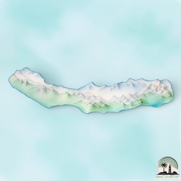
Size: 744.8 km²
Coastline: 178.6 km
Ocean: Atlantic Ocean
Sea: North Atlantic Ocean
Continent: Seven seas (open ocean)
Sao Miguel is a Large Island spanning 745 km² with a coastline of 179 km.
Archipel: Azores – An autonomous region of Portugal in the North Atlantic Ocean, known for their volcanic landscapes, rich maritime history, and unique Azorean culture.
Tectonic Plate: Eurasia – One of the world’s largest tectonic plates, the Eurasian Plate covers a significant portion of Europe and Asia. It’s characterized by diverse geological features, including the Ural Mountains, the European Plain, and the Himalayas formed from its collision with the Indian Plate.
The geographic heart of the island is pinpointed at these coordinates:
Latitude: 37.79635282 / Longitude: -25.48099209
Climate and weather of Sao Miguel
Climate Zone: Temperate
Climate Details: Warm-Summer Mediterranean Climate
Temperature: Warm Summer
Climate Characteristics: Characterized by warm, dry summers and mild, wet winters, typical of coastal areas with abundant sunshine Rain is more common in the winter months, maintaining a moderate climate.
Topography and nature of Sao Miguel
Timezone: UTC-01:00
Timezone places: Atlantic/Cape_Verde
Max. Elevation: 949 m
Mean Elevation: 333 m
Vegetation: Evergreen Broadleaf Forest
Tree Coverage: 40%
The mean elevation is 333 m. The highest elevation on the island reaches approximately 949 meters above sea level. The island is characterized by Mountains: High, steeply elevated landforms. Characterized by both a high maximum elevation (over 500 meters) and a high mean elevation, creating rugged, mountainous terrains on islands.
Dominating Vegetation: Evergreen Broadleaf Forest
Characterized by dense, lush canopies of broadleaf trees that retain their leaves year-round. These forests are typically found in tropical and subtropical regions and are known for their high biodiversity. Sao Miguel has a tree cover of 40 %.
Vegetation: 10 vegetation zones – Very Highly Diverse Island
Islands in this range are ecological powerhouses, showcasing a wide array of vegetation zones. Each zone, from lush rainforests to arid scrublands, coastal mangroves to mountainous regions, contributes to a complex and interdependent ecosystem. These islands are often hotspots of biodiversity, supporting numerous species and intricate ecological processes.
Infrastructure and Travelling to Sao Miguel
Does the island have a public airport? yes.
Sao Miguel has a public and scheduled airport. The following airports are located on this island: João Paulo II Airport.
Does the island have a major port? yes.
Sao Miguel is home to a major port. The following ports are situated on the island: .
The mean population of Sao Miguel is 193 per km². Sao Miguel is Moderately Inhabited. The island belongs to Portugal.
The name of the island resonates across different cultures and languages. Here is how it is known around the world: Arabic: جزيرة ساو ميغيل; German: São Miguel; Spanish: São Miguel; French: São Miguel; Portuguese: Ilha de São Miguel; Russian: Сан-Мигел; Chinese: 聖米格爾島
Continuing your journey, Terceira is the next notable island, situated merely km away.
HOW TO TRAVEL AZORES in 2024 (São Miguel Island) | Ultimate 7-Day Itinerary

Portugal is classified as Developed region: nonG7: Developed economies outside of the Group of Seven, characterized by high income and advanced economic structures. The level of income is High income: OECD.
News – Latest Updates and Headlines from Sao Miguel
Stay informed with the most recent news and important headlines from Sao Miguel. Here’s a roundup of the latest developments.
Please note: The data used here has been primarily extracted from satellite readings. Deviations from exact values may occur, particularly regarding the height of elevations and population density. Land area and coastline measurements refer to average values at mean high tide.