Singyat
Welcome to Singyat, a Tropical island in the Bay of Bengal, part of the majestic Indian Ocean. This guide offers a comprehensive overview of what makes Singyat unique – from its geography and climate to its population, infrastructure, and beyond. Dive into the details:
- Geography and Size: Explore the island’s size and location.
- Climate and Weather: Weather patterns and temperature.
- Topography and Nature: Uncover the natural wonders of the island.
- Infrastructure and Travelling: Insights on reaching, staying, and making the most of your visit.
- News and Headlines: Latest News.
Geography and size of Singyat
Size: 164 km²
Coastline: 127.6 km
Ocean: Indian Ocean
Sea: Bay of Bengal
Continent: Asia
Singyat is a Large Island spanning 164 km² with a coastline of 128 km.
Archipel: –
Tectonic Plate: India – A major tectonic plate that initially moved northward at a rapid pace before colliding with the Eurasian Plate. This collision is responsible for the uplift of the Himalayas and the Tibetan Plateau.
The geographic heart of the island is pinpointed at these coordinates:
Latitude: 19.85993557 / Longitude: 93.46641769
Climate and weather of Singyat
Climate Zone: Tropical
Climate Details: Tropical Monsoon Climate
Temperature: Hot
Climate Characteristics: Characterized by heavy rainfall, high humidity, and uniformly high temperatures, but with a distinct short dry season. It features a seasonal reversal of prevailing wind directions.
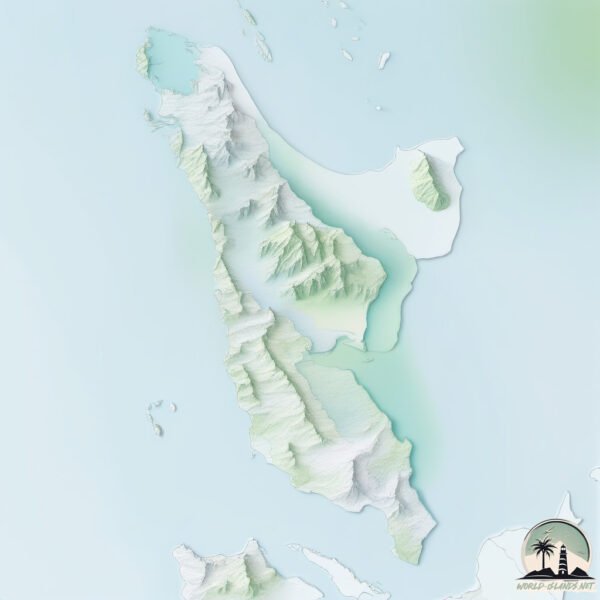
Topography and nature of Singyat
Timezone: UTC+06:30
Timezone places: Asia/Rangoon
Max. Elevation: 376 m
Mean Elevation: 97 m
Vegetation: Evergreen Broadleaf Forest
Tree Coverage: 70%
The mean elevation is 97 m. The highest elevation on the island reaches approximately 376 meters above sea level. The island is characterized by Hills: Gently sloping landforms with rounded tops, having a maximum elevation between 200 and 500 meters. Hills contribute to a varied landscape on islands.
Dominating Vegetation: Evergreen Broadleaf Forest
Characterized by dense, lush canopies of broadleaf trees that retain their leaves year-round. These forests are typically found in tropical and subtropical regions and are known for their high biodiversity. Singyat has a tree cover of 70 %.
Vegetation: 14 vegetation zones – Exceptionally Diverse Island
Islands with more than ten vegetation zones are among the most ecologically rich and varied in the world. These islands are akin to miniature continents, boasting an incredible array of ecosystems. The sheer range of habitats, from high peaks to deep valleys, rainforests to deserts, creates a mosaic of life that is unparalleled. They are crucial for conservation and ecological studies.
Infrastructure and Travelling to Singyat
Does the island have a public airport? no.
There is no public and scheduled airport on Singyat. The nearest airport is Kyaukpyu Airport, located 34 km away.
Does the island have a major port? no.
There are no major ports on Singyat. The closest major port is SITTWE, approximately 58 km away.
The mean population of Singyat is 59 per km². Singyat is Gently Populated. The island belongs to Myanmar.
Continuing your journey, Taunghray is the next notable island, situated merely km away.
Choi San Dou (財神到)
Myanmar is classified as Least developed region: Countries that exhibit the lowest indicators of socioeconomic development, with the lowest Human Development Index ratings. The level of income is Low income.
News – Latest Updates and Headlines from Singyat
Stay informed with the most recent news and important headlines from Singyat. Here’s a roundup of the latest developments.
Please note: The data used here has been primarily extracted from satellite readings. Deviations from exact values may occur, particularly regarding the height of elevations and population density. Land area and coastline measurements refer to average values at mean high tide.