
Ullit Island
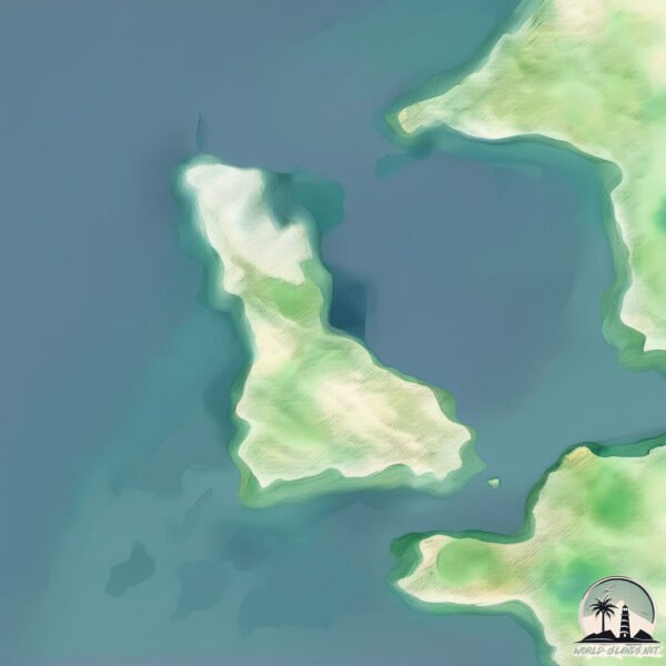
Welcome to Ullit Island, a Polar island in the The Northwestern Passages, part of the majestic Arctic Ocean. This guide offers a comprehensive overview of what makes Ullit Island unique – from its geography and climate to its population, infrastructure, and beyond. Dive into the details:
- Geography and Size: Explore the island’s size and location.
- Climate and Weather: Weather patterns and temperature.
- Topography and Nature: Uncover the natural wonders of the island.
- Infrastructure and Travelling: Insights on reaching, staying, and making the most of your visit.
- News and Headlines: Latest News.
Geography and size of Ullit Island
Size: 3.982 km²
Coastline: 16.3 km
Ocean: Arctic Ocean
Sea: The Northwestern Passages
Continent: North America
Ullit Island is a Small Island spanning 4 km² with a coastline of 16.3 km.
Archipel: Canadian Arctic Archipelago – A vast and remote region in northern Canada, consisting of a series of large and small islands known for their extreme Arctic environment and unique wildlife.
Tectonic Plate: North America – Covers North America and parts of the Atlantic and Arctic Oceans, characterized by diverse geological features and varying levels of seismic activity.
The geographic heart of the island is pinpointed at these coordinates:
Latitude: 69.16355774 / Longitude: -75.61120313
Climate and weather of Ullit Island
Climate Zone: Polar
Climate Details: Tundra
Temperature: Cold
Climate Characteristics: The tundra climate features long, extremely cold winters and short, cool summers. Vegetation is limited to mosses, lichens, and small shrubs due to the low temperatures and short growing seasons. Biodiversity is low, but some specialized species thrive.
Topography and nature of Ullit Island
Timezone: UTC-05:00
Timezone places: America/New_York
Max. Elevation: -6 m
Mean Elevation: -11 m
Vegetation: Herbaceous Cover
Tree Coverage: 60%
The mean elevation is -11 m. Remarkably, this unique island barely emerges above the sea level, showcasing nature’s fascinating interplay with the ocean. The island is characterized by Plains: Flat, low-lying lands characterized by a maximum elevation of up to 200 meters. On islands, plains are typically coastal lowlands or central flat areas.
Dominating Vegetation: Herbaceous Cover
Comprising mainly of grasses, herbs, and ferns, these areas are common in prairies, meadows, and savannas, and can vary widely in species composition. Ullit Island has a tree cover of 60 %.
Vegetation: 3 vegetation zones – Moderately Diverse Island
These islands start to show a broader range of ecological niches. With three vegetation zones, they may offer a mix of ecosystems like coastal areas, inland woods, and perhaps a distinct wetland or dry area. This diversity supports a wider range of flora and fauna, making these islands more ecologically complex than those with minimal diversity.
Infrastructure and Travelling to Ullit Island
Does the island have a public airport? no.
There is no public and scheduled airport on Ullit Island. The nearest airport is Pond Inlet Airport, located 467 km away.
Does the island have a major port? no.
There are no major ports on Ullit Island. The closest major port is POND INLET, approximately 415 km away.
The mean population of Ullit Island is 0 per km². Ullit Island is Uninhabited. The island belongs to Canada.
Continuing your journey, Murray is the next notable island, situated merely km away.
Canada is classified as Developed region: G7: Group of Seven – Major advanced economies, including Canada, France, Germany, Italy, Japan, the United Kingdom, and the United States. The level of income is High income: OECD.
News – Latest Updates and Headlines from Ullit Island
Stay informed with the most recent news and important headlines from Ullit Island. Here’s a roundup of the latest developments.
- Tyler Murray recaps the Mustangs' Week 5 win over Bishop Kenny - Florida Todayby "Murray island" - Google News on 18 September 2026
Tyler Murray recaps the Mustangs' Week 5 win over Bishop Kenny Florida Today
- Bob Murray: Pinocchio and the perils of Pleasure Island - Guernsey Pressby "Murray island" - Google News on 17 September 2026
Bob Murray: Pinocchio and the perils of Pleasure Island Guernsey Press
- Look at the new Pine Island State Park on Lake Murray (Video) - The Stateby "Murray island" - Google News on 10 July 2026
Look at the new Pine Island State Park on Lake Murray (Video) The State
- Pamela Anderson’s Summer Essentials Start at $22 - People.comby "Murray island" - Google News on 9 July 2026
Pamela Anderson’s Summer Essentials Start at $22 People.com
- Quadriplegic senior says home care now 'worse' as delivery of procedure limited to male workers - CBCby "Murray island" - Google News on 22 June 2026
Quadriplegic senior says home care now 'worse' as delivery of procedure limited to male workers CBC
- Charlesetta "Sophia" Bennett-Murray Obituary | Walker-Fielding The Funeral Directors V2 | Johns Island, SC - Tribute Archiveby "Murray island" - Google News on 22 June 2026
Charlesetta "Sophia" Bennett-Murray Obituary | Walker-Fielding The Funeral Directors V2 | Johns Island, SC Tribute Archive
- Mosqueda applauds passage of funding measure for roads desperately in need in White Center, Vashon-Murray Island, more - King County (.gov)by "Murray island" - Google News on 12 June 2026
Mosqueda applauds passage of funding measure for roads desperately in need in White Center, Vashon-Murray Island, more King County (.gov)
- Islands Unlimited gets another £75k - Bailiwick Expressby "Murray island" - Google News on 10 June 2026
Islands Unlimited gets another £75k Bailiwick Express
- Missy Higgins, The Living End and Pete Murray Lead Ocean Sounds 2027 Lineup - Rolling Stone Australiaby "Murray island" - Google News on 3 June 2026
Missy Higgins, The Living End and Pete Murray Lead Ocean Sounds 2027 Lineup Rolling Stone Australia
- Lake Murray’s Doolittle Island reveals World War II training legacy - WIS News 10by "Murray island" - Google News on 27 April 2026
Lake Murray’s Doolittle Island reveals World War II training legacy WIS News 10
Please note: The data used here has been primarily extracted from satellite readings. Deviations from exact values may occur, particularly regarding the height of elevations and population density. Land area and coastline measurements refer to average values at mean high tide.